6:20 PM Wednesday, May 14, 2025
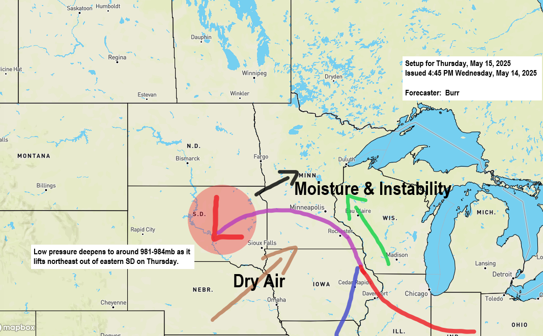
-A strengthening low-pressure system, accompanied by a potent negatively tilted trough, will move northeast into the Upper Midwest on Thursday. This system is anticipated to bring showers and thunderstorms to northeast Minnesota and northwest Wisconsin on Thursday, with additional rainfall expected from Friday into Friday night as moisture circulates around the departing low-pressure system.
-Isolated to scattered strong to severe thunderstorms may occur Thursday afternoon into the early evening, mainly in east central Minnesota and northwest Wisconsin.
-Fog is likely tonight and Thursday near Lake Superior, including the Twin Ports area, due to increasing low-level moisture and east winds from the lake.
-International Falls, Minnesota had its 4th consecutive day of 90-degree weather today, reaching a high of 91. This also marks the 4th straight day of record high temperatures; the previous record for May 14th was 89, set in 1991.
-This month, 4 days over 90 degrees at International Falls makes May 2025 the record for the most 90-degree days. The previous record was 3 days, set in 1986, 1980, and 1919.
Rainfall of up to half an inch is expected in much of the Northland by Friday evening, with some areas receiving over an inch.

The greatest chance for some severe weather Thursday is over northwest Wisconsin in the orange area with the lowest chance in dark green.


Isolated tornadoes may occur Thursday afternoon and early evening, especially in the yellow hatched area on the map, with lower chances farther north.
Note: The tornado risk in the Duluth metropolitan area is minimal on Thursday, as the storms affecting the city are expected to be elevated in nature, with little to no potential for surface-based storms.

Hail about the size of a quarter (1 inch in diameter) is possible especially in the yellow and red areas on the map on Thursday, with the possibility of 2 inch or greater diameter sized hail in the hatched area.

Wind gusts of 60 mph or more are possible on Thursday, with the highest chances in the red area and lower chances in the brown area.

NAM 3km model simulated radar forecast valid 7 AM Thursday to 1 PM Friday.

HRRR model simulated radar forecast valid 7 AM Thursday to 1 PM Friday.

Scattered showers and thunderstorms occurred today, with the greatest coverage in parts of northwest Wisconsin and eastern Minnesota, while more isolated rain was observed in northeast Minnesota. The precipitation remained confined to areas well inland from Lake Superior. Light winds aloft led to slow-moving storms, resulting in torrential downpours in the locations impacted by the storms.
Doppler radar rainfall estimates indicate isolated pockets with over 1 inch of rainfall in the light blue areas, and 2 or more inches of rainfall in the purple areas.

Scattered showers and thunderstorms persist across parts of the Northland this evening; however, these are expected to weaken as the night progresses. Until then, anticipate brief periods of heavy rainfall and lightning should you encounter one these storms.
Radar loop ends 5:58 PM Wednesday, May 14, 2025.
Thanks for reading!
Leave a Reply