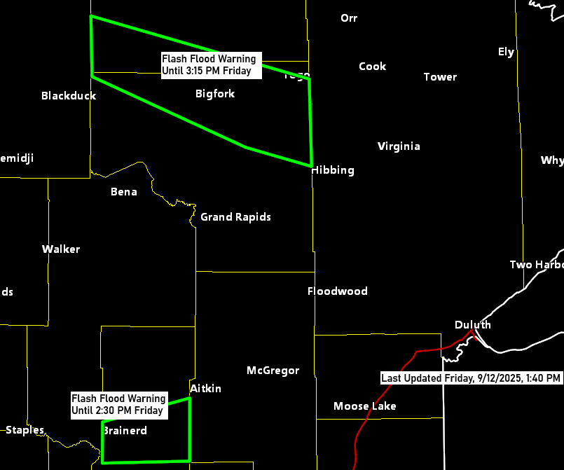
Friday brought plenty of action to the western parts of the Northland as showers and thunderstorms rolled in. Some storms escalated to severe levels, unleashing large hail and heavy downpours, which raised concerns about flash flooding. The affected areas include a stretch from Northome to Effie and Bigfork, as well as another from Brainerd to Garrison.
Radar rainfall estimates range from 1 to 2 inches, with localized totals reaching up to 3 inches near Northome.
Note: A report indicated 1.40 inches of rain fell in just 10 minutes near Brainerd, Minnesota this morning.


The stronger storms that affected parts of the Northland this morning have either moved out or weakened into general showers with occasional thunder, though some heavy downpours are still lingering.
Radar loop ends 1:30 PM Friday, September 12, 2025.
Local Storm Reports for September 12, 2025
- 11:39 AM: Hail 1.25 inch (half dollar sized hail). 1 WSW Brainerd, MN (Crow Wing County)
- 11:36 AM: Hail 0.70 inch. 2 SW Brainerd, MN (Crow Wing County)
- 11:11 AM: Hail 1.50 inch (ping pong ball sized hail). 5 NE Brainerd, MN (Crow Wing County)
- 11:00 AM: Hail 1.00 inch (quarter sized hail). 2 N Pillager, MN (Cass County)
- 10:57 AM: Thunderstorm Wind Gust 66 mph. 4 NE Brainerd, MN (Crow Wing County)
- 10:37 AM: Hail 1.00 inch (quarter sized hail). 3 E East Gull Lake, MN (Crow Wing County)
- 10:28 AM: Hail 1.00 inch (quarter sized hail). 3 NW Motley, MN (Cass County)
Take a look at the GOES-16 infrared satellite loop, which concludes at 1:01 PM on Friday, September 12, 2025.
The deeper red hues indicate cloud top temperatures of approximately -60°C or colder.
Storms today have been developing well north of a warm front, marked by a red line on the map, which is situated near the Minnesota/Iowa state line. Ample warm air and moisture advection north of this front, combined with some instability and steeper mid-level lapse rates, have generated convection in parts of the Northland.

Leave a Reply