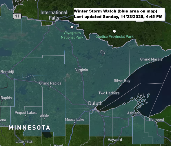
A winter storm watch is in effect for most of northeast and east-central Minnesota, as well as parts of northwest Wisconsin, on Tuesday and Wednesday.

There’s a good chance this watch will be upgraded to a winter storm warning in parts of the Northland, which would mark the first winter storm warning in our area in 234 days.

The overall setup hasn’t changed much over the past 24 hours.
A low-pressure system is expected to form or move over southern Minnesota on Tuesday morning, then deepen slightly as it tracks northeast, reaching the southern and central parts of Lake Superior by early Wednesday morning.
- Precipitation is expected to start during the day Tuesday, with snow most likely in northern Minnesota, and rain or a mix further south, including Duluth, eastern Minnesota, and northwest Wisconsin.
- Areas that see rain should switch to snow Tuesday evening, with the snowfall continuing throughout the night.
- Snow will ease into flurries on Wednesday, while heavier lake-effect snow lingers along the South Shore of Lake Superior in northern Wisconsin.
- The heaviest snowfall from this system is expected Tuesday evening and overnight, with rates of about 1 inch per hour possible in parts of the Northland.
- Northeast winds blowing at 15 to 30 mph on Tuesday will turn to the north-northwest by Tuesday night and into Wednesday. Areas of blowing and drifting snow could occur, especially Tuesday night and Wednesday.
- Temperatures in the 30s on Tuesday will dip into the 20s by Tuesday night and stay fairly steady between the 20s and around 30 degrees through Wednesday.

A look at my preliminary snowfall forecast for Tuesday afternoon through Wednesday, ending at 7 AM.
There will likely be a noticeable drop in snow amounts both north and south of the area expecting the highest totals with this system.
Right now, I’m predicting 3 to 6 inches in the main zone, with 1 to 3 inches expected to the north and south.
It’s possible we’ll see the snowfall gradients shift slightly over the next 24 hours, with totals potentially increasing or decreasing.
It’s worth noting that more lake-effect snow is expected along the South Shore of Lake Superior in northern Wisconsin from Wednesday into Wednesday night, with an additional 3 to 6 inches or more possible. This would be on top of what’s already expected from the main system Tuesday night into Wednesday morning.
For the Duluth area: Most of the accumulating snow from this system is expected to fall Tuesday evening, continuing overnight and lingering until around mid-morning Wednesday. 3 to 6 inches of snow are possible in Duluth by 7 AM on Wednesday.

Make a one-time donation
Make a monthly donation
Make a yearly donation
Choose an amount
Or enter a custom amount
Your contribution is appreciated.
Your contribution is appreciated.
Your contribution is appreciated.
NAM forecast precipitation types valid from midnight Tuesday to 6 PM Wednesday.
Snow – blue
Rain – green

Tuesday’s system is expected to feature a solid temperature gradient, with 850mb readings ranging from about +4°C in southwest Wisconsin to around -7°C in northwest Minnesota.
The coldest air to our west will move east as the system shifts away on Wednesday.

Something to watch with this system is the precipitation types near Lake Superior, as the lake’s water temperature is still about 5 degrees above the late November average, with readings around 40 to 45 degrees.
Northeast winds off the 40-plus degree water might keep near-surface temperatures warm enough for more rain than snow in lower elevations near Lake Superior Tuesday afternoon into the evening. However, colder air is expected to move in, likely switching the precipitation to snow by late Tuesday night, if not sooner.

Leave a Reply