Before getting into the upcoming winter storm, it’s worth noting that Duluth, Minnesota matched its daily record high temperature for November 24th at 53 degrees today. This record was previously set in 1890 and again in 1984.
In Duluth, the average date for the last 50-degree day is November 12, with the latest on record falling on December 22 in 1980. In 2024, the final 50-degree day occurred on November 18.
For the second day in a row, Brainerd, Minnesota set a new daily high temperature record, hitting 53 degrees and beating the previous mark of 52 set in 2006.
Alright, moving on to what’s surely on everyone’s mind today—the incoming system set to bring a mix of accumulating snow and rain to the Northland.
This is likely to be the first widespread significant snow event for the 2025-2026 season, and some parts of the Northland will likely see double-digit snow totals by Wednesday afternoon.
Here’s my forecast for snow totals in the Twin Ports area.
Higher elevations inland from Lake Superior are expected to get about 6 to 8 inches of snow, while lower elevations closer to the lake will likely see around 3 to 6 inches.
- Most of the snow will arrive late Tuesday afternoon, continue through the night, and start tapering off around 5 AM Wednesday morning.
- Expect some rain to develop during the day on Tuesday, gradually turning to snow in the afternoon—starting in the higher elevations and then moving into the lower elevations later in the day.
- Northeast winds will pick up on Tuesday, with gusts around 20 to 35 mph. By Tuesday night and into Wednesday, winds will shift to the north-northwest, still bringing gusts in the 20 to 35 mph range.
- Temperatures will fall from about 33 to 38 degrees during the day on Tuesday to roughly 20 degrees early Wednesday morning.
- Snow totals near Lake Superior will hinge on how quickly the rain changes to snow. If that switch happens later than anticipated, amounts could be closer to 3 inches instead of 6.

Snowfall amounts are expected to decrease significantly on the north side of the system, and its slightly more southerly path has resulted in less snow for northern Minnesota and the Arrowhead region.
The heaviest snowfall is expected along the south shore of Lake Superior in northern Wisconsin, with system and lake-enhanced snow Tuesday night and Wednesday bringing the possibility of 10 or more inches.
The rest of northwest Wisconsin and parts of east central Minnesota, stretching up to Two Harbors and Silver Bay, are expected to see around 4 to 8 inches of snow.
This is my snowfall forecast for all of northeast Minnesota and northwest Wisconsin through 12 PM on Wednesday.

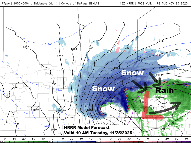
Expect precipitation to develop across the Northland on Tuesday, with snow in the western and northern regions and rain in northwest Wisconsin and eastern Minnesota.
The rain/snow line will push farther south and east Tuesday afternoon into early evening, with all of northeast Minnesota and northwest Wisconsin getting snow by mid to late Tuesday evening.
Snow will gradually ease from west to east on Wednesday, though lake-effect snow will persist throughout the day in northern Wisconsin near Lake Superior.
Here’s the NAM-Nest precipitation type forecast from 6 AM Tuesday to 12 PM Wednesday.
Snow – blue
Rain – green

Here’s a look at the National Weather Service winter weather headlines map for Tuesday through Wednesday.


Strong upward motion in the atmosphere is expected as the mid and upper-level low and trough intensify, which will help bring heavier precipitation to parts of northeast and east-central Minnesota and northwest Wisconsin later Tuesday afternoon into the night, shown by the yellow, orange, and red colors on the loop below.
Snowfall rates of about 0.5 to 1 inch per hour could develop in some of the mentioned areas from late Tuesday afternoon through Tuesday night.
RAP model 500mb forecast valid 6 AM Tuesday to 6 AM Wednesday.

Another sign of this system strengthening as it moves across the upper Midwest on Tuesday is visible in the 500mb anomaly forecast, where blue shades appear, signaling the 500mb low and trough deepening to around -2 sigma from late Tuesday into Wednesday morning. GFS model forecast shown below.

Leave a Reply