The weather is calm across the Northland this Christmas Eve night, but it’s expected to shift a bit on Christmas Day.
As for white Christmas chances in Duluth, yes, we will have a white Christmas this year with a snow depth at the National Weather Service of 6 inches (need at least 1 inch of snow on the ground Christmas morning for a white Christmas).
Since 1916, Duluth has seen only five Christmases without at least an inch of snow on the ground: 2023, 2006, 1979, 1939, and 1923. The record for the most snow on Christmas morning was 28 inches in 1983.
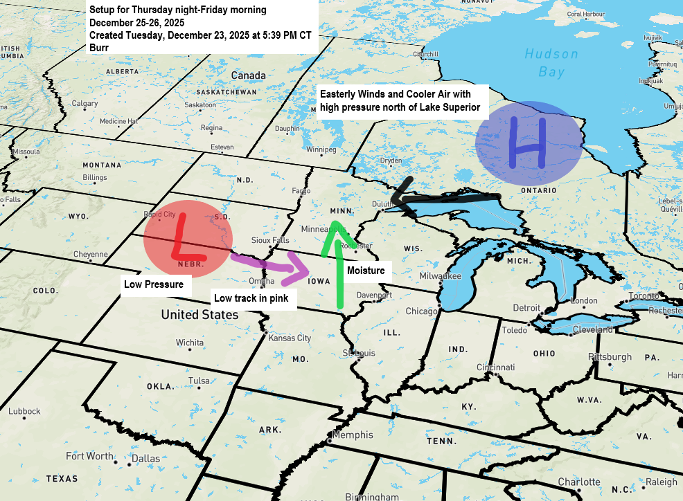
…Moving onto the system for Thursday night…
East winds will pick up near Lake Superior Thursday morning, with gusts of 15 to 30 mph lasting through the day into early evening. As these winds cross the lake, they could bring some spotty lake effect snow or freezing drizzle from the head of the lake along the North Shore, but snowfall should stay under an inch and any icing will likely be minimal, at least until mid-afternoon Thursday.
The most impactful portion of this forecast occurs from roughly late Thursday afternoon or evening till early Friday morning; this is when we could see a mix of freezing rain, sleet, and snow, with snow most likely over the Arrowhead and an icy mix further south, including the Iron Range, Twin Ports, east central Minnesota, and northwest Wisconsin.
Temperatures are expected to be in the 20s to low 30s Thursday night and early Friday morning, then rise to around or above freezing by Friday afternoon.
Note: Precipitation amounts including ice totals and snowfall totals remain uncertain as of late Wednesday afternoon as computer models differ on how much precipitation will see out of this system.
…Ice Accumulation Forecasts…
One of the more extreme forecasts for ice accumulation continues to come from the Euro model, showing widespread icing between 0.05 and 0.25 inches across much of the Northland, including Duluth, on Thursday night.

The Euro Ensemble model predicts ice accumulation in Duluth on Thursday night ranging from 0.05 inches on the low end to 0.29 inches on the high end.

Alongside the Euro model, the RAP model is also indicating significant icing Thursday night in northeast Minnesota and northwest Wisconsin, with amounts possibly reaching or even surpassing a quarter inch in parts of northeast Minnesota.

On the lower end, the NWS Blend of Models, which combines various weather models from both NWS and non-NWS sources, indicates much less icing potential Thursday night, with amounts ranging from just a trace to about 0.05 inches.
Note: If the more extreme forecasts from the Euro and RAP models turn out to be right, we could see winter weather headlines issued for parts of the Northland on Thursday night. Stay tuned.

Not much snow is expected from this system Thursday night, except in the Arrowhead where 1 to 4 inches could fall. Elsewhere in northeast Minnesota, northwest Wisconsin, and Duluth, little to no snow is anticipated.

NAM-Nest simulated radar forecast valid 6 AM Thursday to 6 AM Friday.
Snow – blue
Mix (Sleet/Freezing Rain) – pink and purple
Rain – green

This weekend, a system could bring some snow and mixed precipitation to parts of the Northland late Saturday into Sunday morning, but for now, it doesn’t seem likely to produce significant amounts.
The main highlight will likely be a brief blast of arctic air and gusty winds expected to follow this system from Sunday into Monday.


Leave a Reply