…Sunday’s system…
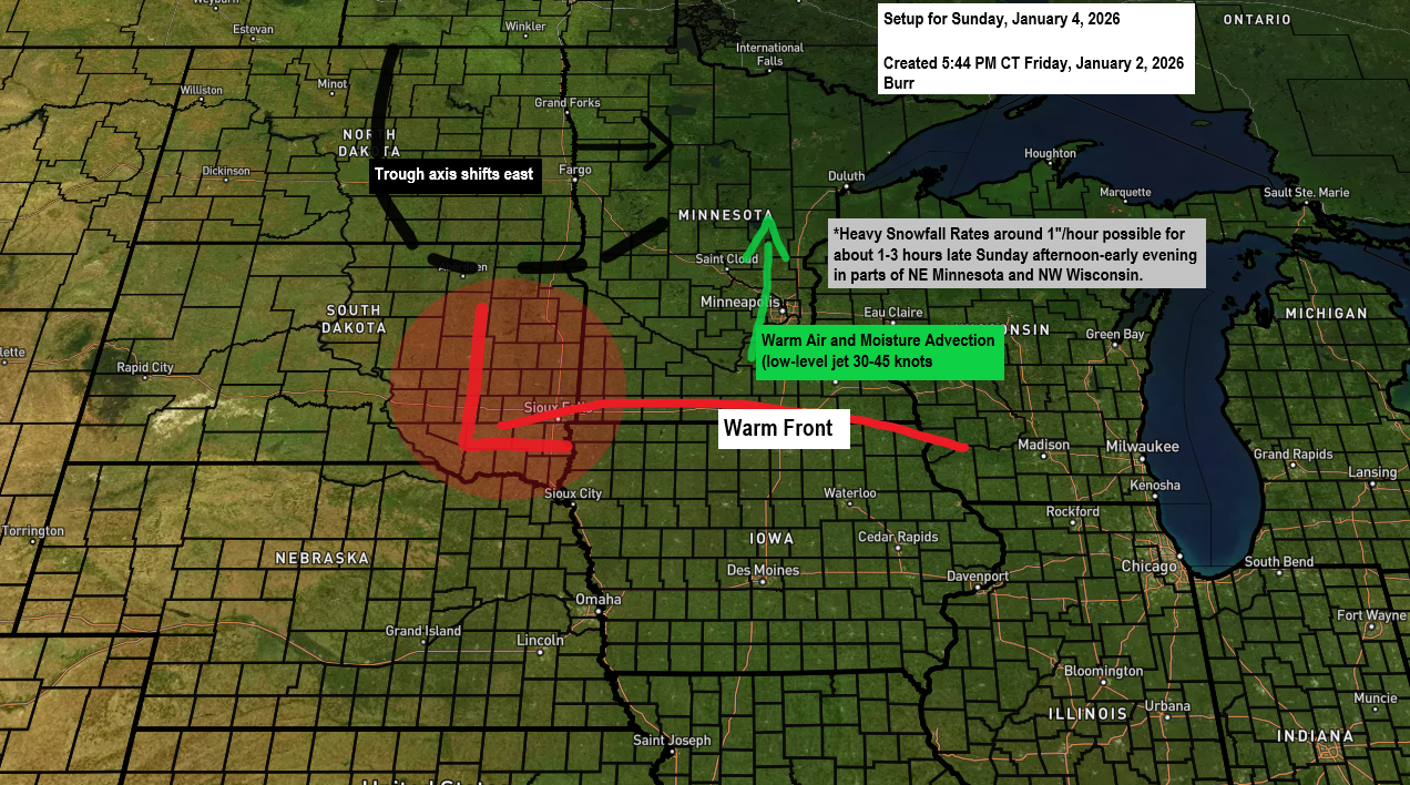
From a dynamics standpoint, Sunday’s system is shaping up to be pretty impressive, with a strong low-level jet developing ahead of it and drawing moist air northward. PWAT values are expected to climb to around 0.5 to 0.65 inches which are unusually high for this time of year. The catch is how fast the system will pass through, likely keeping snowfall totals modest, but snowfall rates could briefly spike to 0.5 to 1 inch per hour late Sunday afternoon or early evening in parts of the Northland.
The heavier snowfall rates are driven by a surge of warm air advection combined with strong FGEN forcing, but these bursts of heavier snow should only last about 1 to 3 hours where they develop late Sunday afternoon.
The main takeaway is that this won’t be a major winter storm with high snow totals in our area, but it’ll hit quickly with a thump of snow late Sunday afternoon and early evening before things settle down late Sunday night.

Today’s model guidance shows a different trough shape, which could affect the type of precipitation expected in northeast Minnesota and northwest Wisconsin on Sunday afternoon and evening.
The Euro model indicates a sharper trough dipping farther south over Minnesota, keeping a cold air mass from the surface to higher levels, resulting in mostly snow.

The RAP model, however, places the trough much farther north over western Ontario, with a flatter flow across Minnesota that allows a warm nose to push east, leading to more of a mix of snow, sleet, and freezing rain.
I’ll see how the models trend over the next 24 hours, but I’m leaning more toward the Euro model than the RAP model.

Here’s a look at my preliminary snowfall forecast for Sunday afternoon through late Sunday night.
Duluth and Superior: Expect 2 to 3 inches of snow, though the quick movement of this system could keep totals lower.
Timing of the snow for Duluth: Stats around 3-5 PM Sunday, ends around 8-10 PM Sunday.
Stay tuned for updates.

Make a one-time donation
Make a monthly donation
Make a yearly donation
Choose an amount
Or enter a custom amount
If my storm updates help you stay ahead of the weather, feel free to toss a few flakes into the tip jar. Thank you.
Your contribution is appreciated.
Your contribution is appreciated.
A clipper moving through late tonight into Saturday morning should bring a little snow to parts of northeast Minnesota and northwest Wisconsin, with accumulations ranging from about 0.5 to 1.5 inches. This snow will once again be on the fluffier side, with higher-than-usual snow-to-liquid ratios due to the cold airmass over the area.
HRRR model simulated radar forecast valid 10 PM tonight to 10 AM Saturday.


Duluth recorded its 15th subzero temperature of the winter this morning, dropping to -5 degrees. Last winter saw 35 subzero nights, which is about average for the entire season (DJF). It’ll be interesting to see how this winter compares.
Temperatures in Duluth should stay above zero tonight, with increased cloud cover helping to keep things a bit milder than the past two nights.
Leave a Reply