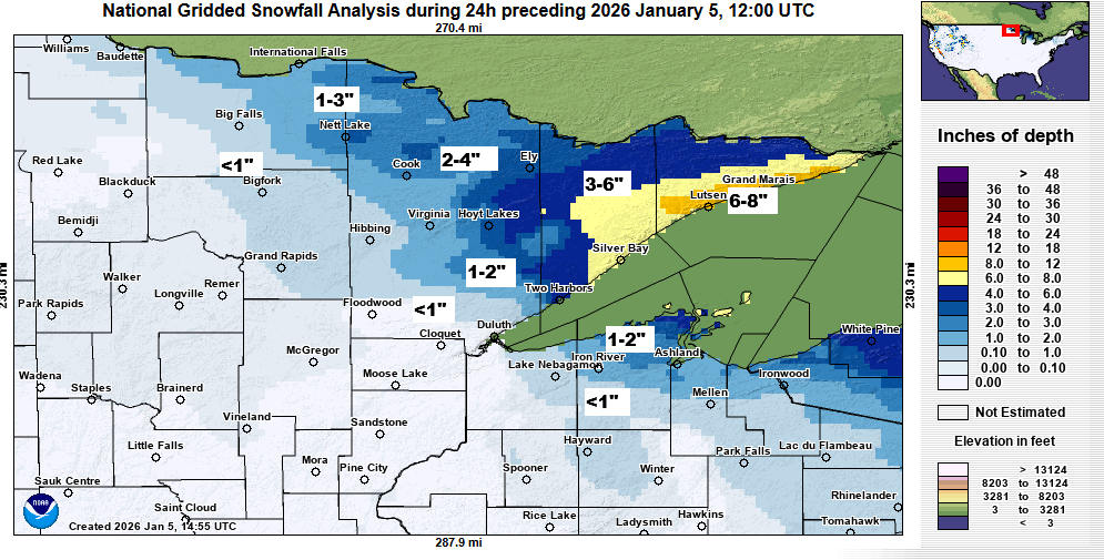
The system on Sunday ended up taking a more northern route, which pushed the higher snow amounts to the Arrowhead of Minnesota, where I was expecting them to occur. However, snow totals did end up higher than I was forecasting, with reports of anywhere from 5 to as much as 8 inches of snow from Lutsen north to Grand Marais and Hovland.
Farther south, the precipitation began as snow, heavy in some areas, but quickly shifted to a mix of sleet, ice pellets, and freezing drizzle.
In Duluth, I had predicted 1 to 2 inches of snow, which was already on the lower side compared to much of the model guidance, but the actual totals came in even lower because of a quick switch to icy precipitation. Officially, the National Weather Service recorded 0.3 inches of snow in Duluth, while the Lester Park area reported 1 inch.
Snowfall report for January 4, 2026
- Hovland, MN: 8.8″
- Grand Marais, MN: 7.5″
- Lutsen, MN: 6.6″
- Sea Gull Lake, MN: 5.8″
- International Falls, MN: 4.6″
- Ely, MN: 4.2″
- Winton, MN: 3.8″
- Silver Bay, MN: 3.8″
- Finland, MN: 3.6″
- Cook, MN: 3.5″
- Wales, MN: 2.5″
- Brimson, MN: 2.3″
- Hoyt Lakes, MN: 2.3″
- Two Harbors, MN: 2.3″
- Herbster, WI: 2.0″
- Biwabik, MN: 2.0″
- Bayfield, WI: 1.9″
- Embarrass, MN: 1.7″
- Red Cliff, WI: 1.7″
- Cornucopia, WI: 1.3″
- Orr, MN: 1.2″
- Washburn, WI: 1.2″
- Lester Park, MN: 1.0″
- French River, MN: 1.0″
- Duluth, MN: 0.3″ (official total at the NWS)
Note: On Sunday, International Falls, Minnesota set a new daily snowfall record with 4.6 inches of snow, surpassing the previous record of 2.8 inches set on January 4, 1949.
Leave a Reply