Bitterly cold air will remain over the Northland this weekend.
Temperatures will likely stay below zero again on Saturday, but there is a chance that some areas may climb above zero for a short time Sunday afternoon. If that doesn’t happen Sunday afternoon, then Monday afternoon’s temperatures look to rise above zero in some parts of the area. Overall, a very cold pattern looks like it will stick around through much of next week.
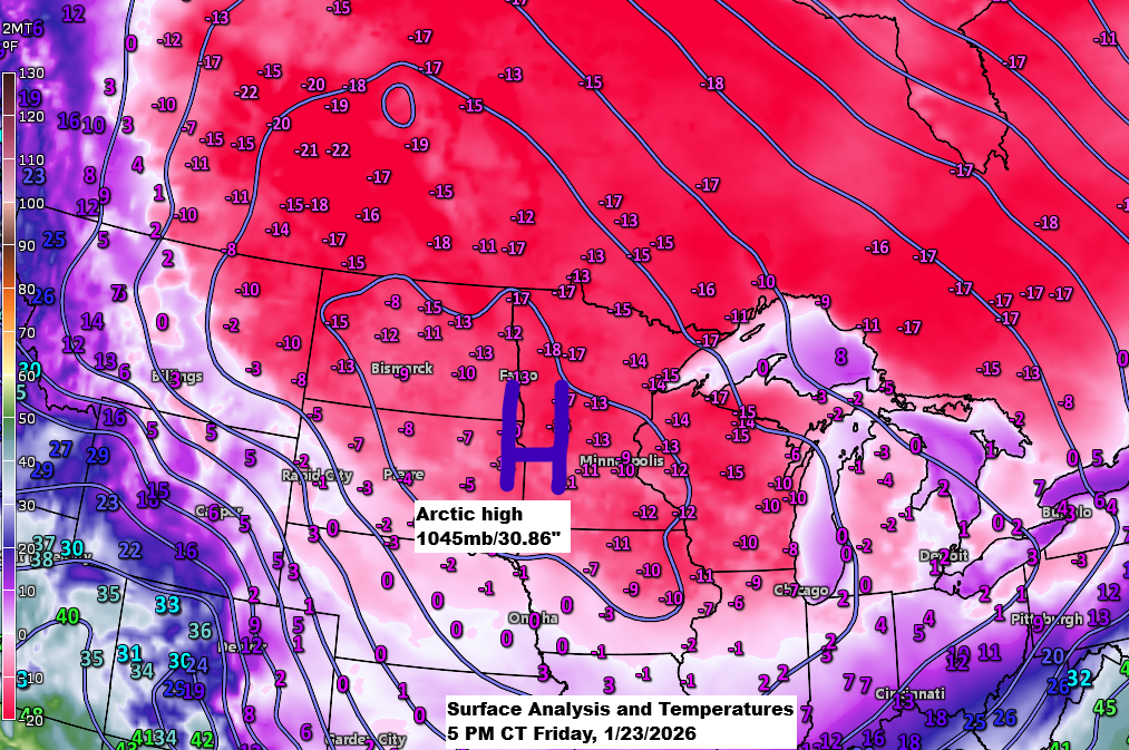
Cold air is widespread today, even though the main part of the polar vortex or mid-level low that was north of Lake Superior on Thursday afternoon has shifted into Quebec, taking the coldest 850mb temperatures and lowest 500mb heights with it. Still, an arctic air mass remains firmly in place in its wake.

This morning was so cold that the GOES-19 infrared satellite imagery showed the frigid air as stationary blue and green areas on the loop, while the moving blue and green spots represented clouds earlier in the day.

…Cold weather alerts continue…
An extreme cold warning remains in effect until 12 PM Saturday for all of northeast Minnesota and northwest Wisconsin, with wind chills dropping between -40 and -45 degrees.

A cold weather advisory is in effect for all of northeast Minnesota and northwest Wisconsin from 6 PM Saturday until 12 PM Sunday, with wind chills forecast to plunge to about 40 degrees below zero.

Widespread temperatures in the -20s and -30s were recorded across northeast Minnesota and northwest Wisconsin on Friday morning, with several notable low temperature reports coming in from the area.
- Cook, MN: -38
- Ash Lake, MN: -37
- Floodwood, MN: -35
- Ely, MN: -35
- International Falls, MN: -33
Friday morning’s official low in Duluth was a frigid -29 degrees, with Superior Airport hitting -27 degrees and Duluth Sky Harbor Airport not far behind at -24 degrees.

Friday morning brought dangerously low wind chills, and here are some of the lowest reports.
- Grand Marais Airport: -63
- Namakagon, WI: -58
- Duluth Airport: -57
- Isabella, MN: -56
- Ely, MN: -55
- Hibbing, MN: -55
- Cable, WI: -54
- Cloquet, MN: -53
- Brainerd, MN: -52
- Ashland, WI: -51

Highs today, if you can call them that, hovered between about -8 and -13 degrees in northeast Minnesota and northwest Wisconsin, roughly 30 degrees below the average for January 23.
Note: Hibbing, Minnesota hit a new record for the coldest daily high today, reaching just -11 degrees. The previous coldest high for January 23 was -7 degrees, set back in 1987.

Low temperatures tonight look similar to last night, ranging from the 20s to 30s below zero, although we may see a few spots dip close to -40 degrees with lighter winds tonight compared to last night.
...Here are the record-low temperatures for January 24...
International Falls: -40 set in 1966
Brainerd: -40 set in 1904 and 1936
Duluth: -37 set in 1904
Ashland: -35 set in 1048
Hibbing: -31 set in 1961, 1987 and 2008
Note: Saturday’s highs are expected to range from about -3 to -13 degrees across northeast Minnesota and northwest Wisconsin.
…Record Daily Coldest High Temperatures for January 24…
- Duluth: -20 set in 1904
- International Falls: -20 set in 1897
- Brainerd: -10 set in 1904
- Hibbing: -10 set in 1961
- Ashland: -3 set in 1936
…Winter Storm this weekend…
A massive winter storm is set to affect areas from the southern Plains through the Ohio Valley and into the Northeast U.S. this weekend, sticking around into Monday for regions farther east.

This weekend’s winter storm is taking shape across the Southwest and parts of the southern Plains, with moisture flowing in from the Pacific and a surge of arctic air pushing down from the northern U.S.
Goes-19 water vapor loop ending 5:20 PM CT Friday, January 23, 2026.

NAM 3km model simulated radar forecast through 12 AM CT Monday.

A broad area from the southern Plains to the Northeast U.S. is expected to see significant snowfall this weekend, with totals of 6 to 12 inches or more, and lighter amounts further north and south.

This weekend, parts of the South and eastern U.S. are expected to see significant ice buildup, ranging from a quarter to half an inch or more.

Leave a Reply