Not a whole lot in terms of active weather for the rest of this week in the Northland, with only a little snow possible early Wednesday morning and again early Thursday morning. However, accumulations should only be in the trace to half-inch range for most, except in the Arrowhead, where about 1 to 2 inches of snow could fall Thursday morning.
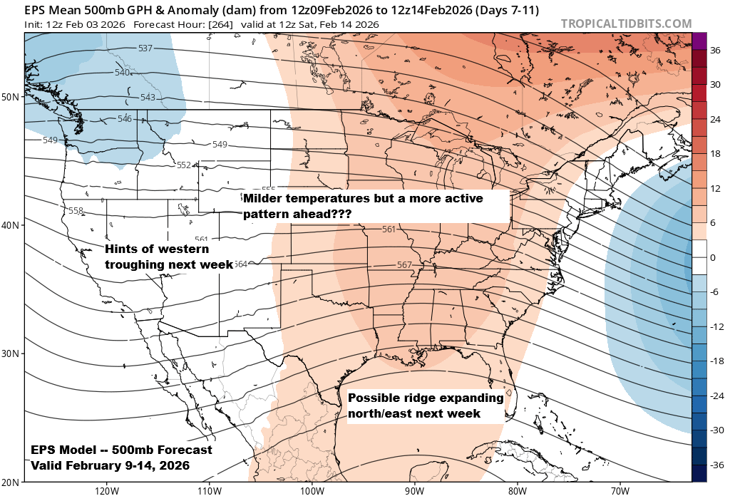
Looking ahead to next week, computer models continue to hint at a more active weather pattern in the upper Midwest. We could see some troughing develop across the western U.S., which has been mostly absent all winter, while a ridge may expand north and east from the Gulf. This setup could send a couple of systems out of the Rockies, and if they follow a favorable track, northeast Minnesota and northwest Wisconsin might see some wintry precipitation at times. It’s still too early to know if any of it will be significant, but there’s a chance for a more notable event sometime next week or the week after.
Here’s the NWS Blend of Models snowfall forecast valid through 6 a.m. on Friday, February 5, 2026.

NAM 3km model simulated radar forecast through 7 AM Thursday.

A warmup is still on track for Thursday, with temperatures in northeast Minnesota and northwest Wisconsin climbing into the 30s to around 40 degrees. However, another blast of cold air is expected to move in on Friday, though the core of this arctic air mass appears likely to pass off to our east.

As expected, temperatures kicked off on a frigid note Tuesday morning, with widespread readings in the teens and 20s below zero across northeast Minnesota. Here are some of the coldest temperatures recorded today.
- Seagull Lake, MN: -29
- Ash Lake, MN: -28
- Cook, MN: -27
- International Falls, MN: -25
- Effie, MN: -22
- Nashwauk, MN: -22
- Cotton, MN: -22
- Cass Lake, MN: -20
Note: Duluth Airport saw a temperature of -8 degrees Tuesday morning, marking the 33rd subzero night of the winter. With the average number of subzero nights during winter (December–February) being 35, it’s likely we’ll reach or even surpass that average by the end of the month.
Lows tonight/Wednesday morning should be a little milder than they were Tuesday morning and will range from around 10 below to the single digits above zero across the Northland.

Leave a Reply