Duluth picked up 1.1 inches of snow today (Tuesday, February 24, 2026), with 0.09 inches of liquid precipitation, giving this clipper a snowfall ratio of roughly 12:1.
Month‑to‑date snowfall in Duluth stands at 14.3 inches, which is 1.5 inches above normal. For the 2025–2026 season as a whole, we’re up to 53.0 inches, running 12.2 inches below average as of February 24.
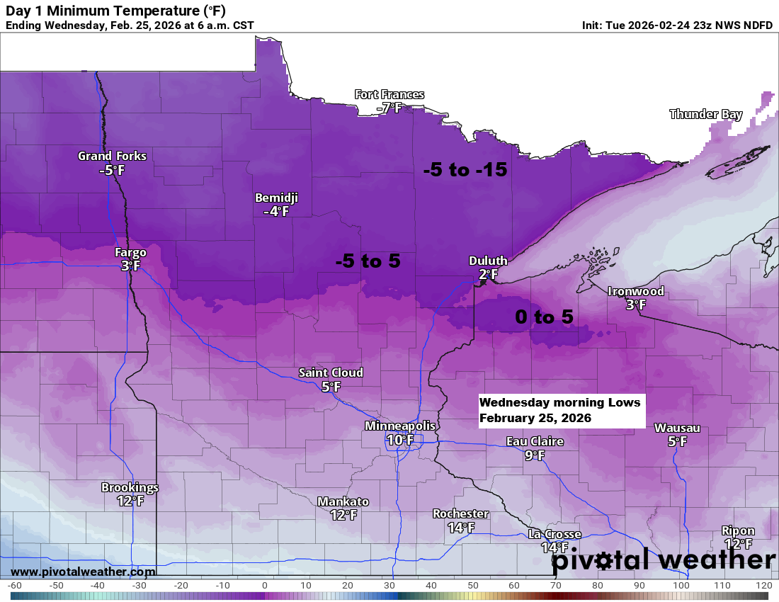
It’s a true temperature roller coaster for the rest of the week. Colder air returns tonight, with some spots dipping back below zero. By Thursday afternoon, though, much of northeast Minnesota and northwest Wisconsin will rebound into the 30s to around 40°F, with similar highs in the 30s and 40s on Friday. The warm spell won’t last long — another surge of Arctic air arrives this weekend, sending temperatures tumbling once again.
...Here’s a look at the forecasted highs for Friday…
There’s a pretty good chance we will reach the low to possibly mid 40s in Duluth Friday afternoon.

It was a changeable day of weather across the Northland. Some areas saw a burst of moderate to heavy snow this morning, along with pockets of freezing rain and ice pellets as a clipper low tracked just north of the region. By afternoon, a push of warmer air brought a very different feel — even some sunshine in spots — with temperatures climbing into the 30s across northwest Wisconsin, east‑central Minnesota, and the Twin Ports.

Another quick burst of snow is possible early Thursday morning across northeast Minnesota and far northern Wisconsin as a warmer airmass begins to move in. Accumulations look light — generally an inch or less — but it may be enough to create a brief period of slick travel before temperatures climb Thursday into Friday.

…Long Range…
Model guidance is hinting at another pattern shift as we head into early March, with the potential for a trough to redevelop across the western U.S. and some upper‑level ridging building over the South and East. If this setup materializes, it would open the door to more frequent precipitation chances in the Northland. All three major ensemble systems are on board, showing roughly 0.50 inches to over 1 inch of total precipitation through March 11.


Leave a Reply