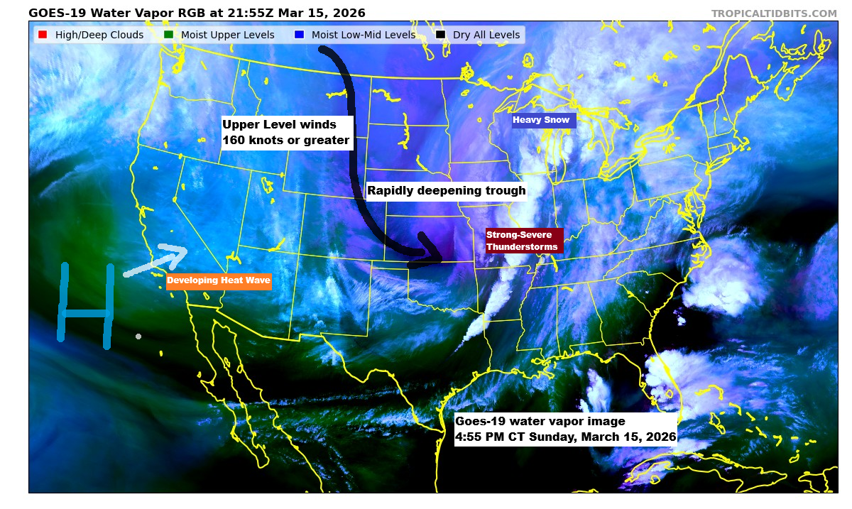
A huge storm system is rolling through today, bringing all kinds of wild weather. Heavy snow and blizzard conditions are slamming parts of the upper Midwest and western Great Lakes, while a line of strong to severe thunderstorms—with multiple warnings and a couple of tornado alerts—stretches from southwest Illinois down to northeast Texas this afternoon.
Interestingly, Missouri is experiencing quite the weather mix today, with severe thunderstorm and tornado warnings in the eastern part of the state and snow squall warnings in the west late this afternoon. Pretty wild!
Radar loop ends 4:48 PM CT Sunday, March 15, 2026.
Snow showers will persist tonight across northwest Wisconsin and nearby areas of northeast and far eastern Minnesota, tapering off from northwest to southeast as the night goes on.
HRRR model simulated radar forecast through 9 AM Monday.

Some areas in northwest Wisconsin might get an additional 1 to 3 inches of snow tonight, with a few spots possibly seeing more than 3 inches.
In Duluth, an inch or less of additional snow is expected this evening.

Late this afternoon, a strong low-pressure system settled over eastern Illinois near Chicago and will track northeast across lower Michigan into early Monday morning. Out west, an arctic high over the northern Rockies will drift east into the upper Midwest over the coming days.
A tight pressure gradient exists between the low to the southeast and the high to the west, and this will continue to produce gusty north to northwest winds in the Northland tonight and Monday, with gusts of 15 to 30 mph and, at times, over 40 mph, especially near Lake Superior. These winds will continue to produce areas of blowing and drifting snow in parts of the Northland through Monday morning, with reduced visibility.
Warm air dominates east of the storm today, with highs in the 70s, while frigid temps in the teens grip the northern Plains.
The next few days in the Northland are going to be chilly, with highs only in the teens to low 20s on Monday and Tuesday—well below normal for mid-March. Some spots will see subzero lows Monday morning and again Tuesday morning, with Tuesday being the coldest. A few places could even drop to around 15 to 20 degrees below zero.

In the mid and upper levels, a large and rapidly deepening trough is developing over the central U.S., set to become negatively tilted as a closed 500mb low forms over the central and eastern Great Lakes early Monday morning. The entire system will then move off to the northeast by Tuesday.
Out west, a huge upper-level ridge packed with heat is gearing up to spread into the southwestern U.S. this week.

Goes-19 infrared satellite loop ending 4:55 PM CT Sunday, March 15, 2026.

A clipper system may bring light snow to much of the Northland, spreading from northwest to southeast Tuesday night. Current forecasts suggest 1 to 2 inches of snow could fall with this system.
NAM 3km model simulated radar forecast valid 1 PM Tuesday to 1 AM Wednesday.

Tornado watches stretch from northeast Texas up to central Illinois and will stay in effect until late tonight.

On Monday, a large-scale severe weather outbreak is expected to stretch from the Southeast to the Mid-Atlantic, bringing threats of damaging winds, large hail, and tornadoes, with some potentially being intense (EF-2 or stronger).

Leave a Reply