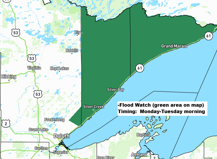
Widespread rain totals of about a half inch to an inch or more are expected in northeast Minnesota and northwest Wisconsin by late Monday night.
This rain on already saturated soils in the Arrowhead of Minnesota and along the North Shore of Lake Superior may lead to excessive runoff and flooding of rivers, creeks, and low-lying areas, especially in poor drainage and urban locations from Monday into Tuesday morning.

Duluth area: Look forward to a rainy Monday with breezy northeast winds at 15–30 mph, patches of fog, and temperatures hovering in the 40s.
NAM 3km model simulated radar forecast through 1 AM Tuesday.

Late this afternoon, a strong low-pressure system averaging 994mb, or 29.35 inches, was centered over northwest Texas, northeast New Mexico, far western Oklahoma, and far southeast Colorado. It’s not expected to deepen much as it moves northeast, reaching western Wisconsin near Eau Claire by 7 PM Monday. From there, it will continue its track northeast, moving north of Lake Superior on Tuesday.
This system will bring widespread light to moderate rain to northeast Minnesota and northwest Wisconsin from late tonight through Monday evening, with the rain tapering off from west to east late Monday night.
Breezy northeast winds are expected near Lake Superior, thanks to the pressure difference between a high over the northern Rockies and a low moving in from the southern Plains. Wind gusts of 15 to 30 mph are likely in the area tonight and Monday.
Fog may also develop in areas near Lake Superior tonight and into Monday.

A typical temperature clash fuels larger low pressure systems this time of year, with cold air dipping into the Rockies and warm, humid air surging northeast ahead of the system.

This spring has been busy with severe weather, and that trend continues Monday with the chance of severe thunderstorms across parts of the Midwest. The risk could stretch as far north as far southern Minnesota and southern Wisconsin, though it’s a bit lower there compared to areas farther south.

A classic spring storm is rolling through, with enough cold air on the back side to bring some snow (shown in blue on the map) today in the northern Rockies. Meanwhile, severe thunderstorms are expected tonight in parts of the central and southern Plains, with a chance for a few tornadoes, large hail and damaging winds in the warm, humid, and unstable air of the system’s warm sector.
Radar loop ends 5:54 PM CT Sunday, April 26, 2026.
Goes-19 water vapor loop ending 6:05 PM CT Sunday, April 26, 2026.

A look at the rainfall analysis for the 24-hour period ending at 1 p.m. Sunday.

First round rainfall totals from Saturday evening through Sunday morning, April 25–26, 2026.
Cotton, MN: 0.73″
Tamarack, MN: 0.51″
McGregor, MN: 0.49″
Deerwood, MN: 0.45″
Wright, MN: 0.45″
Isabella, MN: 0.42″
Hermantown, MN: 0.42″
Eveleth, MN: 0.36″
Palisade, MN: 0.35″
Brainerd, MN: 0.34″
Swan River, MN: 0.30″
Ely, MN: 0.29″
Grand Marais, MN: 0.29″
Saginaw, MN: 0.28″
Aurora, MN: 0.27″
Aitkin, MN: 0.25″
French River, MN: 0.23″
Two Harbors, MN: 0.22″
Solon Springs, WI: 0.21″
Embarrass, MN: 0.20″
Knife River, MN: 0.20″
Pine City, MN: 0.20″
Esko, MN: 0.19″
East Gull Lake, MN: 0.16″
Silver Bay, MN: 0.15″
Minong, WI: 0.14″
Superior Airport: 0.12″
Poplar, WI: 0.12″
Hill City, MN: 0.11″
Bruno, MN: 0.11″
Lutsen, MN: 0.11″
Brule, WI: 0.09″
Keewatin, MN: 0.06″
Danbury, WI: 0.05″
Siren, WI: 0.04″
Grand Rapids, MN: 0.04″
Hayward, WI: 0.03″
Thanks to huntingonhere for the donation to the Northlandweather blog, it’s truly appreciated.
Make a one-time donation
Make a monthly donation
Make a yearly donation
Choose an amount
Or enter a custom amount
Thank you for backing this work — your support makes a real difference.
Your contribution is appreciated.
Your contribution is appreciated.
Leave a Reply