Early this morning, the first round of rain passed through parts of the Northland, and tonight will bring the second and final round with this system. Much like last night, the expected rainfall totals don’t appear to be very significant.
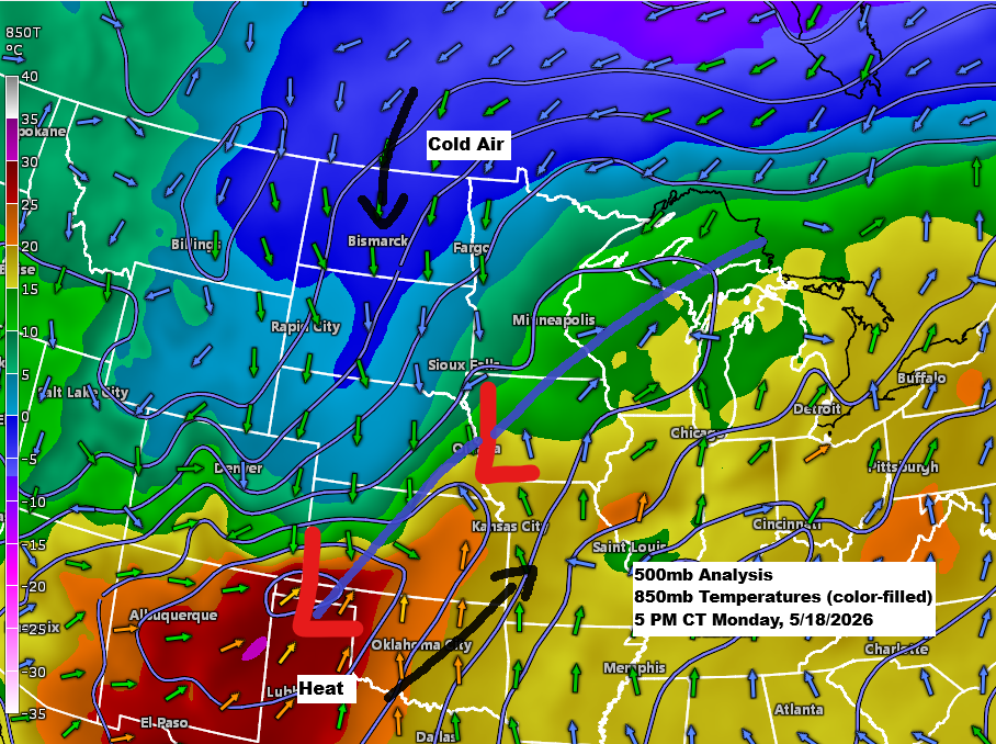
This is a classic spring setup, with a few low-pressure systems moving northeast from the central Plains along a frontal boundary that separates colder air to the northwest from warm, muggy air to the southeast.
Our area remains in the cooler, more stable part of the system, so the chance for strong or severe thunderstorms is basically nonexistent tonight, just like last night. However, a few isolated, non-severe thunderstorms could still pop up this evening in eastern Minnesota and northwest Wisconsin.
Tonight’s rain is forming over western Minnesota and is moving into central Minnesota late this afternoon. It will continue to lift northeast through the night, leaving the area early Tuesday morning.
Gusty northeast winds of 15 to 30 mph are expected for a few hours tonight near Lake Superior, including Duluth. By Tuesday, winds will shift to the northwest, bringing similar gusts across the entire Northland.
Radar loop ends 5:44 PM CT Monday, May 18, 2026
Tonight, rainfall in northeast Minnesota and northwest Wisconsin is expected to range from 0.10 to 0.25 inches, with some spots possibly seeing up to half an inch or more.

There’s a chance that enough cold air could wrap into the backside of tonight’s system to bring a mix of rain and snow for a few hours Tuesday morning across far northern Minnesota, including the International Falls area, though it’s unlikely any snow would stick.

With much warmer, more humid, and unstable air in place, there’s a risk of severe thunderstorms this evening across parts of the southern and central Plains into the Ohio Valley, with a couple of watches currently in effect.

GOES-19 water vapor loop ending at 5:50 PM CT on Monday, May 18, 2026, with tornado, severe thunderstorm, and flash flood warnings overlaid.
Red and pink polygons – Tornado Warning
Yellow polygons – Severe Thunderstorm Warning
Green polygons – Flash Flood Warning
Leave a Reply