This afternoon, scattered showers and thunderstorms rolled through the southern parts of the Northland, driven by warm, humid, unstable air. With light winds near the surface and weak winds higher up, the storms have been short-lived—forming, building up, and fading within about an hour. A few hit severe levels, bringing quarter-size hail and winds between 40 and 60 mph.
The showers and thunderstorms will wrap up by mid to late evening, bringing on several dry days for northeast Minnesota and northwest Wisconsin.
Radar loop ends 5:24 PM Tuesday, May 26, 2026.
This is a cross-section radar image showing two storms from this afternoon near Brainerd and McGrath, MN.
This cross section shows a tall, vigorous updraft, a well-defined anvil, strong ice formation, a precipitation-heavy downdraft, and solid vertical structure.
The core climbs to about 45,000 to 50,000 feet, with a mostly vertical updraft column.

Slow-moving, pulse-type scattered thunderstorms over the southern parts of the Northland have been bringing heavy rainfall this afternoon, with radar estimating between 0.50 and over 1 inch of rain in very localized areas.

Watching convection form on visible satellite imagery is always fascinating.
GOES-19 visible satellite loop ending on Tuesday, May 26, 2026, at 4:50 PM CT.
For the second day in a row, Hibbing, Minnesota has matched or broken its daily record high temperature.
*=Tied daily record high
***=New daily record high
May 25th:
High: *87
Record high: 87 set in 2010
May 26th:
High: ***89
Record high: 88 set in 1978
Monday brought warm weather to much of the Northland, but today (Tuesday) turned out even hotter, with several spots in the area hitting 90 degrees this afternoon, see below.
- Bigfork, MN
- Grand Rapids, MN
- Longville, MN
- Pine River, MN
- Brainerd, MN
- Hinckley, MN
- Siren, WI
- Winter, WI

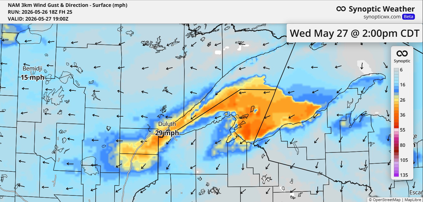
Temperatures in the Twin Ports were mild again today, ranging from about 80 degrees on top of the hill to the mid-60s at Duluth Sky Harbor Airport, and the lower 70s in Superior. On Wednesday, a stronger push of cool lake air will move into Duluth, keeping temps in the 40s near the lake and in the 50s to lower 60s on top of the hill. Winds from the east-northeast could gust up to 30 mph.
It looks like Duluth will enjoy a brief return of warmth on Friday, with highs in the 80s, before much cooler temperatures move in on Saturday, accompanied by gusty northeast winds.

The current pattern is an absolute mess, with no sign of improvement anytime soon, but this kind of chaotic jet stream activity is pretty typical during an El Niño.
L=Mid and upper level low/trough
H=Upper level high/ridge

Leave a Reply