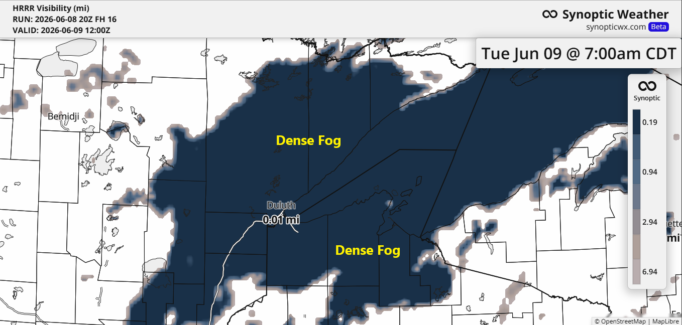
Humid air from Lake Superior will create widespread fog around the lake tonight into Tuesday morning, reducing visibility to a quarter mile or less in some areas. The fog is expected to clear by Tuesday afternoon, but more dense fog may return Tuesday evening and linger until Wednesday morning.

…Severe Weather Potential Tuesday (6/9)…
Strong to severe thunderstorms are expected to form over the Dakotas late Tuesday afternoon or evening. They’ll likely move northeast into Wednesday morning but should weaken a bit by the time they reach northeast Minnesota and northwest Wisconsin, if they make it to our area at all.
Tuesday night’s storms could bring damaging winds and large hail, with the highest risk in the orange-shaded area on the map. A few tornadoes are also possible, mainly across the Dakotas.
Note: Early Wednesday morning, parts of the Northland could see isolated gusty winds or hail, with the highest chances in the western areas.

…Severe Weather Potential Wednesday (6/10)…
Severe thunderstorms are more likely across the Northland on Wednesday afternoon and evening, as both a warm front and a cold front move through the region, accompanied by a strong low-pressure system passing over Manitoba.
How Wednesday unfolds is uncertain, as much will depend on how Tuesday night’s convection develops and whether it affects parts of the Northland Wednesday morning.
However, conditions are lining up for the potential of severe thunderstorms Wednesday afternoon and evening, with high CAPE or storm energy, plenty of boundary layer moisture (dew points between 62 and 72 degrees), favorable wind shear, and strong upper-level support. Because of this, the Enhanced Risk or level 3/5 for severe weather has been expanded to include east central Minnesota and all of northwest Wisconsin, while areas farther north face a slight risk or level 2/5.
On Wednesday, damaging winds and large hail will be the primary threats, though a few tornadoes could also form, particularly in east-central Minnesota and northwest Wisconsin.

The upper-level pattern by itself strongly suggests the potential for a significant severe weather event across parts of Minnesota and Wisconsin on Wednesday.
In the upper levels, there’s a broad southwest flow with good curvature and diffluence overhead, which is ideal for deep-layer shear and broad ascent. This pattern could support supercell storm development in eastern Minnesota into Wisconsin if the other necessary ingredients come together.


…Temperatures and Dew Points…
Away from Lake Superior, it was another warm afternoon with highs in the 70s to around 80 degrees, though cloud cover kept things slightly cooler. Closer to the lake, within about 15 miles, temperatures were much cooler again today, mostly staying in 50s.
Temperatures in the 50s are expected near Lake Superior on Tuesday and Wednesday with persistent east winds, while inland areas will warm up to the 80s on Tuesday and the 70s and 80s on Wednesday.
As I mentioned in my Sunday post, these temperatures are indeed warmer than usual for early June (except near Lake Superior), but they aren’t setting any high temperature records.

Dew points are running high again today, ranging from the mid-60s to around 70 degrees in northeast Minnesota and northwest Wisconsin, making it feel pretty muggy outside.
It will stay muggy away from Lake Superior on Tuesday and Wednesday, with dew points lingering in the 60s to low 70s.
Note: With the much cooler temperatures near Lake Superior, the dew points are naturally much lower.

Leave a Reply