Severe thunderstorms possible in the Northland Wednesday, June 10, 2026.
Although it’s still a few days away and things could change by Wednesday, the setup for severe weather is looking quite favorable in northeast Minnesota and northwest Wisconsin for Wednesday afternoon and evening.
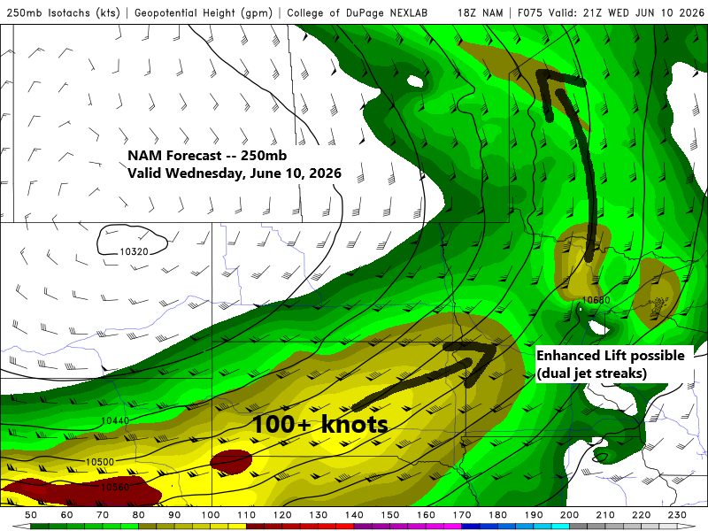
Sunday’s model runs show a very favorable upper-level pattern, with strong winds aloft and a dual jet streak—one to the north and another approaching from the southwest—featuring 100+ kt winds, southwest flow, a trough west of the region, and strong divergence aloft. This setup could support anything from supercells to a significant squall line, depending on how low-level moisture and instability develop.
The surface setup shows a fairly strong low lifting northeast out of the Dakotas, with both a warm front and a cold front moving across the Northland. The timing of this system is still a bit uncertain, and how Tuesday’s convection develops to our west—and how long it sticks around if it reaches the Northland late Tuesday night into Wednesday morning—could influence what happens Wednesday afternoon and evening.

Moisture is expected to build ahead of Wednesday’s system, with dew points in the 60s and possibly climbing into the low to mid-70s across eastern Minnesota and western Wisconsin.

Here’s the severe weather outlook issued by the Storm Prediction Center valid for this coming Wednesday. Expect some changes to this outlook in the coming days.
Strong winds, hail, and a few tornadoes are possible on Wednesday in the yellow and orange zones, with the greatest risk in the orange-shaded region.

Leave a Reply