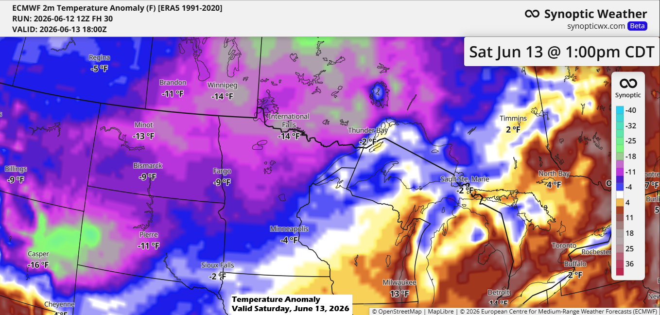
Much cooler weather is heading into the Northland, with Saturday’s highs expected to be around 15 degrees below normal in northern Minnesota, only reaching the 50s. Elsewhere in the Northland, it’ll be a bit warmer with highs mostly in the 60s, though still about 5 to 10 degrees below average for June 13th.
Here’s a look at the record low high temperatures for June 13th.
Note, the records below should be safe on Saturday.
- Duluth, MN: 45 set in 1884
- International Falls, MN: 49 set in 1908
- Hibbing, MN: 52 set in 1989
- Ashland, WI: 53 set in 1941
- Brainerd, MN: 55 set in 2025
The cool weather on Saturday is thanks to chilly 850mb temperatures dropping to around +1 to +5°C across the Northland, which is about -2 sigma for June 13th according to GFS model data.

A cold front will sweep through the area tonight, bringing scattered showers and a few thunderstorms, with the greatest chance for thunderstorms from southern Minnesota to western Wisconsin.
NAM 3km model simulated radar forecast through 7 AM Saturday.

Widespread rain isn’t expected with tonight’s front; instead, there will be a few scattered showers that could bring around 0.05 to 0.25 inches of rain, with much of the Northland likely seeing little to no precipitation.

This afternoon, clouds have been drifting across northeast Minnesota and northwest Wisconsin, with just a few brief moments of sunshine breaking through.
Clouds are expected to be fairly widespread across the area on Saturday, while Sunday is shaping up to be the sunnier day of the weekend.
Goes-19 visible satellite loop ending 5:31 PM CT Friday, June 12, 2026.
With the cloud cover over the area temperatures in the Northland were mostly in the 60s to lower 70s today.

On Thursday, June 11, 2026, roughly two dozen tornadoes, marked by red icons on the map, were reported across parts of the Midwest, especially in Illinois and Indiana, with Iowa and Wisconsin also seeing at least one report each.

Leave a Reply