Northeast Minnesota and northwest Wisconsin are at risk for severe thunderstorms on Monday, June 29.
This outlook serves as a heads-up since there are still questions about the timing of the storms and the primary threats. Given the forecasted setup, it’s no surprise that a severe weather risk area has been issued for parts of the upper Midwest.
Severe thunderstorm probabilities could rise over the next few days, and the outlined area may shift as well. Stay tuned.

On Monday, temperatures are expected to climb into the 80s and low 90s across much of northeast Minnesota and northwest Wisconsin, with mid 90s to low 100s possible in central and southern Minnesota.
Northeast breezes are expected near Lake Superior on Monday, keeping temperatures noticeably cooler within roughly 15 to 20 miles of the lake.

Temperatures will be one story on Monday, but the dewpoint is another, expected to climb into the low to mid-70s for areas away from Lake Superior. A real steamer!
These high dew points are expected to stick around for most of next week, and even near Lake Superior, things could get pretty steamy on certain days—it’ll all depend on the wind direction.

Grateful for your support — Venmo: @tburrj5
Make a one-time donation
Make a monthly donation
Make a yearly donation
Choose an amount
Or enter a custom amount
Your contribution is appreciated.
Your contribution is appreciated.
Your contribution is appreciated.
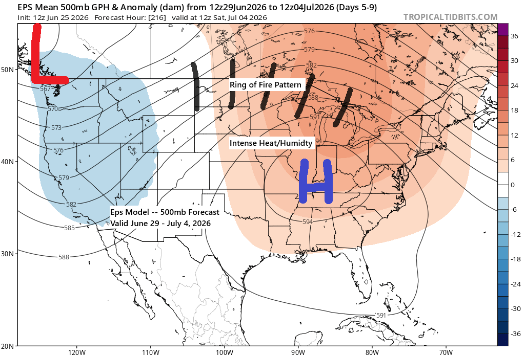
…Setup for next week…
Ring of Fire type pattern setting up
Late this weekend into early next week, a warm front will push north from southern Minnesota, while a cold front is likely to stall in the upper Midwest for much of the week.
The atmosphere will be loaded with moisture next week as dew points rise into the 65 to 75 degree range, with highs reaching the 80s and possibly pushing into the 90s depending on cloud cover and timing of storms. There will also be plenty of potential energy, with CAPE values topping 2500-4000 J/kg for much of the week.
Showers and thunderstorms are possible at times across much of the Northland for several days next week, and the setup is worth keeping an eye on as it could bring damaging winds.
Overall, it’s a classic summer pattern, with a strong ridge bringing intense heat and humidity a bit farther south, while strong winds aloft sweep across the northern tier. Disturbances moving over the ridge could trigger clusters of strong to severe thunderstorms at times next week from the northern Plains to the Great Lakes.

A big question for next Monday is whether the strong cap with 700mb temperatures between +14 and +17°C will hold over the Northland, or if enough forcing from the boundaries will trigger thunderstorms and severe weather. With these kinds of forecasted temperatures at 700mb, the cap is often too strong to break, so it will be interesting to see if models trend a few degrees cooler in the coming days or stay the same.

…Today’s weather…
A few isolated showers have passed through far northern Minnesota and the Arrowhead region today, but they should taper off by late this evening.
Radar loop ends 5:45 PM Thursday, June 25, 2026.
…Popup afternoon showers Friday…
A few isolated showers may pop up again Friday afternoon into the evening, mainly favoring northern Wisconsin and eastern Minnesota.
HRRR model simulated radar forecast valid 1 PM Friday to Midnight.
Leave a Reply