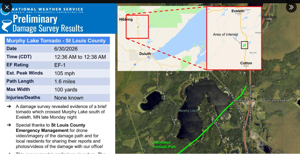
Early Tuesday morning, June 30, 2026, a brief tornado touched down over Murphy Lake in central St. Louis County, Minnesota.
Rating: EF-1
Estimated Peak Wind: 105 mph
Path length: 1.6 miles
Path width: 100 yards
Fatalities: 0
Injuries: 0
Start date: June 30, 2026
Start time: 12:36 AM
Start location: 5 miles east-southeast of Zim
End date: June 30, 2026
End time: 12:38 AM
End location: 5 miles northwest of Melrude
EF Scale
EF0 – Weak 65-85 mph
EF1 – Weak 86-110 mph
EF2 – Strong 111-135 mph
EF3 – Strong 136-165 mph
EF4 – Violent 166-200 mph
EF5 – Violent >200 mph
…Weather Summary…
A frontal boundary will linger across the upper Midwest, stretching from west to east or west to east-northeast through Friday, before sliding further south over the weekend.
The Northland is seeing plenty of warm air and moisture today, along with some instability, with CAPE values reaching up to 1500 J/kg. However, lapse rates and wind shear are both fairly weak, so while scattered showers and thunderstorms will pop up in parts of the area tonight, the risk for severe storms is low. That said, the strongest storms could still bring some hail and gusty winds. Heavy rain is also likely where storms hit, thanks to PWATs near 1.50 inches and dew points in the 60s.
HRRR model simulated radar forecast through 7 AM Friday.
Tonight’s forecast is uncertain, but a narrow stretch in northeast Minnesota and far northern Wisconsin, around or between the black lines on the map, could get some heavy rain totaling half an inch to an inch or more.

…Friday-Saturday…
The differences between the Euro and NWS Blend of Models persist today, with the Euro projecting a drier outlook for much of northeast Minnesota and northwest Wisconsin. This is especially the case for areas near Lake Superior, including Duluth, where little to no rain is expected through 7 PM Saturday.

The NWS Blend of Models and other models predict a few rounds of showers and possible thunderstorms across the Northland through 7 PM Saturday, with Duluth expecting half an inch or more of rain and heavier amounts to the west and south.

…Temperatures and Dewpoints…
It was another warm day in the Northland, with temperatures hovering in the 80s.
From Friday into the weekend, winds will shift to the east, bringing cooler temperatures near Lake Superior with highs in the 60s on Friday and in the 50s and 60s over the weekend. Inland areas will stay warmer, with highs ranging from the 70s to low 80s from Friday through Sunday.

Dew points climbed into the 60s to low 70s in our area today, with drier air in the far northern regions. It’ll remain somewhat humid on Friday, but lower dew points are expected this weekend.

Leave a Reply