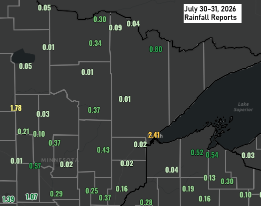
It was definitely a strange rainfall pattern this time, with many spots across the Northland seeing only about a quarter to half inch or less. But one area really stood out — at the head of Lake Superior, where a band of heavier rain parked itself for a few hours Friday morning, dropping 1 to 2 inches from Floodwood and Meadowlands over to the north side of Duluth.
The rainfall gradient with this system was striking, dropping from 2.41 inches at the Duluth Airport to just 0.06 inches in Palmers, only about 20 miles—or roughly a half-hour drive—apart. Meanwhile, Duluth Sky Harbor Airport, just 11 miles from Duluth Airport, picked up only 0.33 inches of rain Friday morning.
On July 31, 2026, Duluth broke its rainfall record with 2.41 inches at the Duluth Airport, topping the previous 1.55-inch mark that had held strong since 1879—a remarkable 147 years.
With more than 2 inches of rain in Duluth today, we’ve pushed past the July average, hitting 4.69 inches in total—0.77 inches above normal. It’s amazing how quickly things can turn around.
Since June 1st, Duluth has received almost 9 inches of rain (8.97 inches), which is 0.66 inches above the average.
Rainfall Reports for July 30-31, 2026
- Hermantown, MN: 2.49″
- Meadowlands, MN: 2.46″
- Duluth Airport: 2.41″
- Palisade, MN: 2.05″
- Burnett, MN: 1.46″
- Floodwood, MN: 1.19″
- Esko, MN: 1.04″
- Saginaw, MN: 0.91″
- Meander, MN: 0.80″
- Aitkin, MN: 0.68″
- Ashland, WI: 0.54″
- McGregor, MN: 0.43″
- Scanlon, MN: 0.39″
- Grand Rapids, MN: 0.37″
- Pine River, MN: 0.37″
- Duluth Sky Harbor Airport: 0.33″
- International Falls, MN: 0.30″
- Glidden, WI: 0.30″
- Siren, WI: 0.28″
- Maple, WI: 0.23″
- Grantsburg, WI: 0.20″
- Hayward, WI: 0.19″
- Danbury, WI: 0.18″
- Hill City, MN: 0.17″
- Hinckley, MN: 0.16″
- Winter, WI: 0.16″
- Spooner, WI: 0.14″
- Wolf Ridge, MN: 0.14″
- Clam Lake, WI: 0.13″
- Poplar, WI: 0.12″
- Trego Lake, WI: 0.11″
- Pleasant Valley, MN: 0.10″
- Minong, WI: 0.09″
- Bayfield, WI: 0.06″
- Palmers, MN: 0.06″
- Solon Springs, WI: 0.04″
- Odanah, WI: 0.04″
- Walker, MN: 0.03″
- Moose Lake, MN: 0.02″
- Brainerd, MN: 0.02″
- Bigfork, MN: 0.01″
- Hibbing, MN: 0.01″
- French River, MN: 0.01″
- Side Lake, MN: 0.01″

The 12-hour radar loop below begins around 1:30 AM Friday and wraps up early Friday afternoon.
The heavy rain and embedded thunderstorms really picked up around 7 this morning, then eased off by late morning. In the Duluth area, the most intense rainfall happened between 7 and 10 AM on Friday.
I’m grateful for everyone who reads, shares, and supports this space. It means a lot.
Make a one-time donation
Make a monthly donation
Make a yearly donation
Choose an amount
Or enter a custom amount
Thank you for supporting the blog!
Your contribution is appreciated.
Your contribution is appreciated.
This was quite a weather system across the Midwest for this time of year.
Goes-19 water vapor loop ending 5:36 PM CT Friday, July 31, 2026.

The low-pressure system that helped bring today’s rain was over eastern Iowa late this afternoon and will keep moving southeast tonight. Meanwhile, a cold front lingering over the Northland this afternoon also sparked some rain earlier in the day. This front will slowly drift south through Saturday.
Note: This weekend looks mostly dry across northeast Minnesota and northwest Wisconsin, with comfortable, seasonable highs in the 70s to low 80s. An east wind might keep it a bit cooler near Lake Superior. Dew points will drop to more pleasant levels, staying in the 50s to around 60 degrees.

Leave a Reply