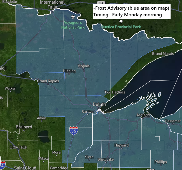
A frost advisory is in effect for early Monday morning, from midnight to 8 AM, covering much of northeast Minnesota and all of northwest Wisconsin.
Temperatures dropping to 33–35 degrees in the advisory area are expected to cause scattered frost early Monday morning.
The highest risk for patchy frost will occur inland from Lake Superior.
Here’s an overview of the average date for the first 32-degree temperature across the Northland, along with the earliest and latest recorded occurrences.
Hayward, WI
Average: September 14
Earliest: August 20 (1934)
Latest: October 15 (2021)
Hibbing, MN
Average: September 15
Earliest: August 13 (2004)
Latest: October 18 (1960)
International Falls, MN
Average: September 15
Earliest: August 20 (1907)
Latest: October 17 (2021)
Ashland, WI
Average: September 18
Earliest: August 18 (1950)
Latest: October 18 (2021)
Brainerd, MN
Average: September 22
Earliest: August 6 (1977)
Latest: October 18 (2013)
Superior, WI
Average: September 30
Earliest: August 20 (1950)
Latest: November 18 (2016)
Duluth, MN
Average: October 1
Earliest: August 27 (1986)
Latest: November 6 (1900)
Over the past 30 days, northwest Wisconsin has remained relatively dry, receiving only 10 to 50% of its normal rainfall, while northeast Minnesota has experienced more frequent showers, with totals reaching approximately 110 to 150% of normal.

Another round of rain is expected in the Northland on Monday
Based on the latest forecast from early Sunday afternoon, much of northwest Wisconsin could receive half an inch or more of rain during Monday’s event, while northeast Minnesota is expected to see amounts ranging from 0.25 to 0.75 inches or higher.

For the Duluth area: Rain is expected to start Monday afternoon, between 1 and 3 PM, and will taper off around midnight.
HRW-ARW M2 simulated radar forecast, valid from 7 AM Monday through 7 AM Tuesday.
Monday’s system will bring cool temperatures to the Northland, reaching the 50s to low or mid-60s before rain arrives, then dropping into the 50s as the rain begins in areas that had warmed into the 60s.
The system bringing rain to the Northland on Monday is currently over the Pacific Northwest and looks quite impressive. It is expected to move quickly east-northeast, reaching central Canada by Tuesday.
Goes-19 water vapor loop from Sunday, September 13, 2026, spanning 7:35 AM to 1:25 PM CT.
Leave a Reply