Another near miss in Duluth this morning, with temperatures dipping to 33 degrees, meaning the wait continues for the first official freeze of the 2026 fall season. There’s a strong chance we’ll surpass the next date on record, October 30th, when the first freeze occurred in Duluth back in 1877. Could we reach the top of the list, November 6, set in 1900? Time will tell.
Latest 1st freeze dates on record for Duluth, MN
1: November 6, 1900
2: November 5, 1894
3: November 1, 1931 & 1882
4: October 30, 1877
…System for tonight and Tuesday…
For Duluth: Rain is expected to start later tonight between 10 PM and midnight, continuing through the night and into Tuesday morning before tapering off by mid to late Tuesday afternoon. Patchy fog may also develop on Tuesday.
MRMS radar loop from Monday, October 26, 2026, loop time ends 5:24 PM CT.
Rain – green
Snow – blue
From east central Minnesota to northwest Wisconsin, rainfall could reach half an inch or more by Tuesday afternoon, while northern Minnesota and the Arrowhead are expected to see amounts between 0.05 and 0.25 inches.
Precipitation anomalies for October 2026, recorded up to 4 PM on the 26th.
- Brainerd, MN: -1.87″
- Duluth, MN: -1.50″
- Hibbing, MN: -1.18″
- Ashland, WI: -0.85″
- International Falls, MN: -0.56″
Blend of models total precipitation through 7 PM Tuesday, 10/27/2026.

…Low chance for brief wintry precipitation tonight…
Given dew points in the mid-20s across northern Minnesota this afternoon, evaporative cooling may be sufficient to lower temperatures enough for a brief period of snow or a rain/snow mix tonight. Despite the potential changeover, little to no snow accumulation is expected.

This afternoon, temperatures in northern Minnesota are in the lower 40s. As precipitation moves north later this evening into the drier air, temperatures are expected to drop by about 7 to 9 degrees, bringing them into the 31 to 35 degree range. This is borderline for wintry precipitation, but in some areas, it could occur overnight.

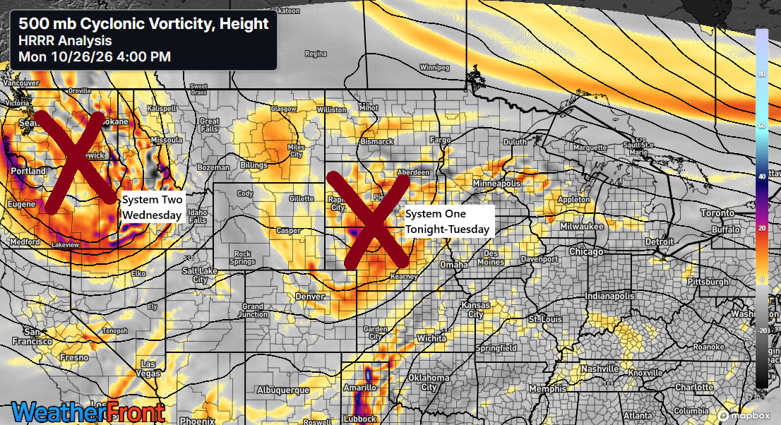
Tonight and Tuesday’s precipitation in the Northland will be due to a low-pressure system moving northeast from southern Nebraska. While this low isn’t very strong, with pressures around 30.21 inches, a strong high over Manitoba at about 30.65 inches will shift east. The pressure difference between the low and high will cause gusty east winds, especially near Lake Superior, where gusts could reach 15–30 mph at times through Tuesday afternoon.

…Second system Wednesday…
Showers are expected to make a comeback in the Northland from Wednesday into Wednesday evening as a cold front moves eastward through the region. There could also be enough elevated CAPE to trigger a few isolated thunderstorms.

GOES-East water vapor loop ending at 5:15 PM CT on Monday, October 26, 2026.
Leave a Reply