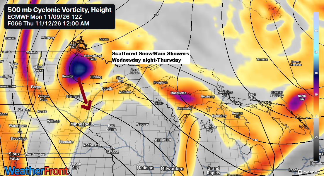
A touch of winter is set to arrive mid to late week, breaking up what has been a pleasantly mild fall.
High temperatures in the Northland will likely struggle to rise above the 30s on Thursday and Friday, but that’s typical for this time of year. While it may feel brisk and chilly, it’s nothing out of the ordinary.
Since October 1, more than 82% of days in Duluth have been warmer than average, with just 10% running below average.

Get ready, snow flurries are in the forecast for Wednesday night and Thursday, with parts of the South Shore of Lake Superior in northern Wisconsin possibly seeing minor accumulations on Thursday. Cold air will be moving across Lake Superior as 850mb temperatures drop to around -10°C, while lake water temperatures remain above average at +8 to +10°C, or about 45-50 degrees.
Note: The last time the Duluth Airport saw at least 0.1 inch of snow was April 5, 2026. Whether we’ll get that much snow later this week is still uncertain, but historically, the average date for such snowfall is October 24. The latest first snowfall of at least 0.1 inch on record happened on November 26, 2004.

Lake Superior water temperatures on November 9, 2026.

Many of us will probably see some flurries or brief snow showers late Wednesday night, lingering into Thursday. I don’t expect much accumulation, maybe just a light coating in some spots, while the South Shore could get up to 2 inches of snow on Thursday thanks to lake effect.

…South Shore Snow Amounts Thursday…

…Long Range Snow Prospects…
Over the next seven days, there are no significant snow events anticipated for northeast Minnesota or northwest Wisconsin, with the 20 GEFS ensemble members showing no potential for major snowfall.

…Rain Showers Tuesday night…
A few rain showers might pass through parts of the Northland Tuesday night, but rainfall amounts are expected to be minimal, around a trace to 0.1 inches.
HRRR model simulated radar forecast valid 4 PM Tuesday to 4 AM Wednesday.
Showers Tuesday night appear confined to a relatively narrow corridor, meaning locations just north or south of the rain band may miss out entirely.

Here’s a look at the highs for November 9th, along with how they compare to the average and what the record high is for that date.
Brainerd, MN
High: 63
Departure: +20 degrees
Record High: 68 set in 1999
Ashland, WI
High: 60
Departure: +17 degrees
Record High: 73 set in 2020
Hibbing, MN
High: 59
Departure: +21 degrees
Record High: 65 set in 1999
International Falls, MN
High: 59
Departure: +21 degrees
Record High: 65 set in 2016
Duluth, MN
High: 57
Departure: +17 degrees
Record High: 71 set in 1999
To put today’s highs into perspective, the record lows for November 9 in our area were all set in 2017, with temperatures dipping to -13 degrees in International Falls, -9 degrees in Hibbing, and 0 degrees in Duluth.
This afternoon brought temperatures well above average, rising into the mid-50s and low-60s.

Leave a Reply