5:50 PM Monday, November 18, 2024
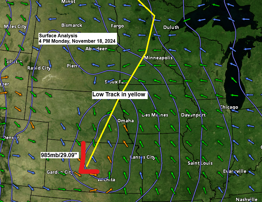
A potent low-pressure area situated southwest of Concordia, KS, late this afternoon is forecasted to move north-northeast into northern Minnesota by Tuesday afternoon. The surface low has been intensifying, with the latest pressure dropping to 983mb/29.03 inches as of 5 PM today. However, it is not expected to deepen significantly further as it progresses into Minnesota.
Duluth area
- Rain is anticipated to start tonight between 7 and 9 PM.
- The heaviest rain is expected overnight tonight until mid-morning Tuesday, although some light rain may continue into the afternoon.
- Expect strong east winds, gusting from 25 to 45 mph, from late tonight into Tuesday morning. The winds will lessen briefly and then increase and shift to the southwest by mid to late afternoon on Tuesday.
- Temperatures are forecast to drop to near the freezing mark by daybreak Wednesday with a possibility for a few snow showers/flurries on Wednesday.
- Gales are expected on western Lake Superior late tonight and into Tuesday, with peak wave heights potentially reaching 14 feet along the North Shore and approximately 5 to 9 feet in the Twin Ports area.
Radar loop ends 5 PM Monday, November 18, 2024.
The Northland will experience rain tonight and into Tuesday. However, a dry slot is expected to move northward and cross the Northland from south to north by Tuesday afternoon or evening. Once this dry slot arrives, the rainfall should diminish.
HRRR model simulated radar forecast through 6 PM Tuesday.

Rainfall Forecast
Widespread rainfall ranging from a half inch to an inch is expected in northeast Minnesota and northwest Wisconsin by Tuesday afternoon, with some areas potentially receiving more than an inch.
The North Shore along Lake Superior is expected to receive 2 to 3 inches of rain, enhanced by the lake and terrain, as easterly winds pass over Lake Superior on Tuesday.

Strong winds tonight and Tuesday
Tonight, the low-level jet is expected to intensify, with 850mb winds ranging from 50 to 70 knots (indicated by red and purple on the loop) passing over the Northland. This will continue from late tonight until mid-morning Tuesday. Some of this wind energy will descend to the surface, driven by heavier rain showers early Tuesday morning. This could result in wind gusts ranging from 20 to 40 mph across parts of the Northland, particularly near Lake Superior, where gusts may hit 50 mph along the North Shore by Tuesday morning.
NAM model 850mb wind forecast valid through 12 PM Tuesday.

Wind Advisories will be in effect from late tonight through Tuesday due to strong east winds, with gusts ranging from 25 to 50 mph. The most intense gusts are anticipated along the North Shore of Lake Superior in northeast Minnesota. These powerful winds may cause tree limbs to fall and lead to potential power outages.

Make a one-time donation
Make a monthly donation
Make a yearly donation
Choose an amount
Or enter a custom amount
Your contribution is appreciated.
Your contribution is appreciated.
Your contribution is appreciated.
DonateDonate monthlyDonate yearlyColder Temperatures
Daytime temperatures in the Northland, ranging from the 40s to lower 50s on Tuesday, are anticipated to drop to the mid-20s to lower 30s by Wednesday morning due to the influx of colder air following an area of low pressure.
Note: The forecast for Duluth indicates temperatures will range from 38 to 41 degrees Fahrenheit at 6 PM on Tuesday, then drop to between 28 and 33 degrees Fahrenheit by Wednesday morning after 4 AM.
HRRR model temperature forecast valid 6 PM Tuesday to 12 PM Wednesday.

As the upper low moves southeastward, showers are expected to redevelop across parts of the Northland from Tuesday night into Wednesday. With the influx of colder air, these showers will transition into snow showers and flurries.
HRRR model simulated radar forecast from 6 PM Tuesday to 12 PM Wednesday.

Snowfall Forecast
The majority of the snow accumulation from this storm is expected across parts of North Dakota and into western Minnesota, with projections of 2 to 4 inches or more. Some locations may even receive more than 6 inches by Wednesday.
Note: Snow accumulations are expected to remain below an inch in parts of the Northland on Wednesday, though there’s a chance for heavier snow squalls that may briefly reduce visibility.


A classic mid-latitude cyclone is ascending north-northeast from the central Plains tonight.
Goes-16 water vapor loop from Monday, November 18, 2024. Loop time ends 5:16 PM CT.

Upper-Level Analysis
A potent upper trough situated over the central Plains is forecasted to ascend northward into the upper Midwest by Tuesday. Associated with this trough are intervals of intense uplift, denoted by the yellow, orange, red, and pink hues on the map. This uplift is expected to traverse the Northland from late tonight until early Tuesday afternoon, resulting in sporadic heavy showers amidst a broader region of light to moderate rain.

Record/near record moisture levels
Forecast models show an increase in precipitable water values to approximately 1 inch, and possibly as high as 1.30 inches, in the Northland from late tonight into Tuesday morning. These values are at or near record highs for this time of year. In other words, this system will be associated with a significant amount of moisture.

Thanks for reading!
Leave a Reply