5:56 PM Saturday, December 14, 2024
My Christmas special will run through December 25. The annual price has dropped from $60 to $35. With a paid subscription to my blog, you’ll have access to early forecasts on upcoming systems that may impact the Northland, as well as snowfall forecasts. The link to subscribe can be found a little further down in this post. Thank you!
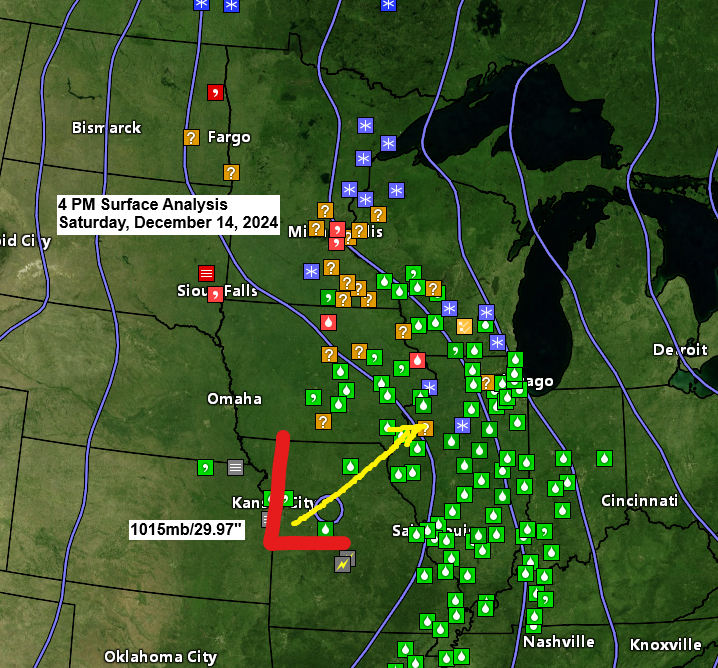
It’s been a messy Saturday in parts of the Midwest as an area of low pressure tracks east-northeast across Missouri.
Warmer air and moisture surging north ahead of this system caused some snow and freezing rain/drizzle in parts of the Upper Midwest today, with the most significant ice accumulations reported in parts of Iowa, where we’ve seen anywhere from 0.20 inches to 0.40 inches of ice accumulation.
The precipitation that occurred in parts of the Northland today has been on the light side, but there’s been enough snow to cause some slippery road conditions. Note: 0.2 inches of snow so far today in Duluth (NWS location).
Also of note, we’ve seen a few severe thunderstorms develop late this afternoon over central Missouri, with a risk of large hail and damaging wind gusts.
Radar loop ends 4:26 PM Saturday, December 14, 2024.
Winter Weather and Fog Alerts
Winter Weather and Dense Fog Advisories are in effect for parts of the upper Midwest tonight and Sunday.
Locally in the Northland, winter weather advisories are in effect through Sunday morning and through 3 PM Sunday for the North Shore, including Duluth.
Areas of light snow along with patchy freezing rain/drizzle are likely in parts of the Northland, including the North Shore and Duluth area tonight and Sunday. Snow accumulations should be under an inch, with a light glaze of ice accumulation also expected.


Dense Fog Possible
Fog, locally dense, will become more widespread in the Northland late tonight, and this fog may persist all the way through early Monday morning. The darker colored areas on the loop below represent visibilities of <1 mile.
HRRR model visibility forecast through 6 AM Monday.

The system over Missouri does look impressive on water vapor imagery today, but the most significant precipitation associated with this system has stayed well south of the Northland today.
Goes-16 water vapor loop ending 4:26 PM CT Saturday, December 14, 2024.


Subscribe to continue reading
Become a paid subscriber to get access to the rest of this post and other exclusive content.