5:15 PM Friday, March 28, 2025
To maintain simplicity, I am publishing two separate posts. The first post will address the system crossing the Northland tonight, while the second post will cover the next system arriving later Saturday afternoon.
Local Storm Reports through 4 PM today, Friday, March 28, 2025
- 4:56 PM: Hail 0.25 inch. 1 N Lake Nebagamon, WI (Douglas County)
- 4:37 PM: Hail 0.75 inch. 3 W South Range, WI (Douglas County)
- 4:34 PM: Hail 0.88 inch. 6 SE Oliver, WI (Douglas County)
- 4:32 PM: Hail 0.70 inch. 3 SE Superior, WI (Douglas County)
- 4:30 PM: Hail 0.50 inch. 1 E Superior, WI (Douglas County)
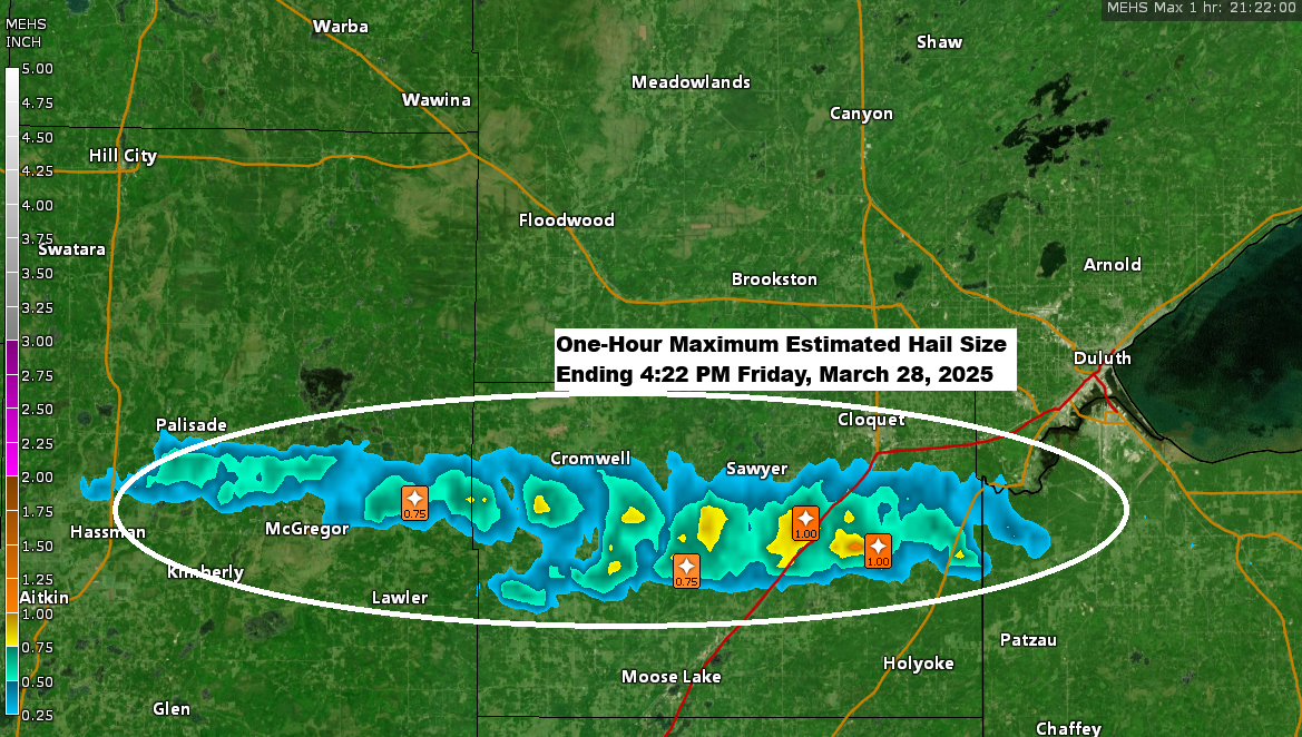
- 4:14 PM: Hail 1.00 inch — Quarter sized hail. 1 SW Scotts Corner, MN (Carlton County)
- 4:11 PM: Hail 1.00 inch — Quarter sized hail. 5 NE Mahtowa, MN (Carlton County) Over an inch of hail on the ground.
- 4:10 PM: Hail 1.00 inch — Quarter sized hail. 3 E Mahtowa, MN (Carlton County)
- 3:56 PM: Hail 0.75 inch. 5 NW Barnum, MN (Carlton County)
- 3:42 PM: Hail 0.40 inch. 2 SSE Tamarack, MN (Aitkin County)
- 3:40 PM: Hail 0.70 inch. 2 SW Tamarack, MN (Aitkin County) Hail accumulated to a measured depth of 0.3 inches.
- 3:17 PM: Hail 0.25 inch. 5 NNW Kimberly, MN (Aitkin County)
- 2:50 PM: FREEZING RAIN 0.25 inches. 2 E Hibbing, MN (St. Louis County)
ICE STORM WARNING until 1 AM tonight for the North Shore of Lake Superior and Arrowhead, mainly in the higher terrain where ice accumulations of 0.20 to 0.40 inches are possible. Significant ice accumulation on power lines and tree limbs may cause widespread and long-lasting power outages.

Winter Weather Advisory (purple area on map) continues for other parts of the Northland through early Saturday morning with ice accumulations of a light glaze to 0.10 inches possible.

It has been tumultuous Friday afternoon across parts of the Northland, with various types of precipitation observed depending on temperature and location. Reports have included freezing rain, sleet, rain, and even some snow.
There was even a severe thunderstorm which passed just south of Duluth late this afternoon around 4 PM with potential for hail of quarter to ping pong ball size.
Radar loop ends around 4 PM Friday, March 28, 2025.
This afternoon, thunderstorms in parts of northeast Minnesota and far northwest Wisconsin have been generating significant lightning activity, partly due to very steep mid-level lapse rates of 7 to 7.5 C/km.
Goes-16 sandwich satellite loop from Friday, March 28, 2025. Loop time ends 4:51 PM CT.
Observe the brighter and colder cloud tops over northeast Minnesota and far northwest Wisconsin today, which indicate the presence convection (thunderstorms) moving across the region.

Low pressure over far southeast South Dakota, combined with a strong warm front across southern Minnesota and southern Wisconsin, caused the messy weather in the Northland today. This low will be moving east and away from the Northland tonight.

We will continue to experience scattered areas of precipitation in the form of freezing rain, sleet, rain, and snow in the Northland tonight. However, this precipitation should diminish from west to east during the night, although some patchy freezing drizzle and fog may persist through the night.
A few thunderstorms will also continue in parts of the Northland this evening.
Euro model simulated radar forecast through 7 AM Saturday.

This temperature contrast we saw today was something else.
80s in southern Minnesota and 30s in northern Minnesota today.

Thanks for reading!
Leave a Reply