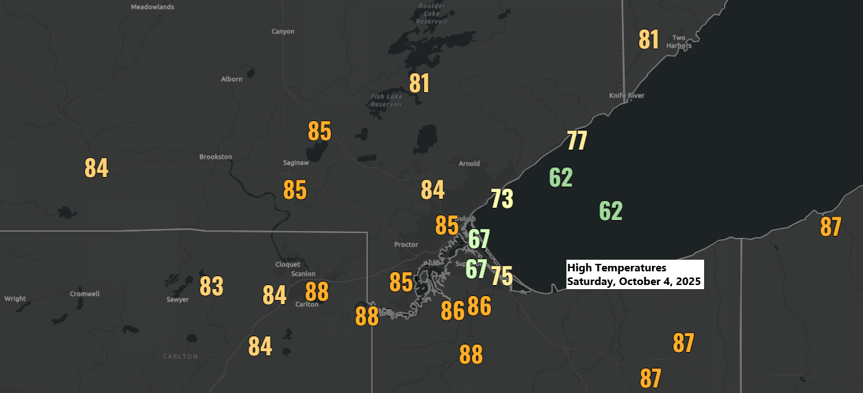
Record-breaking heat engulfs the Northland on this October 4th, 2025.
Northeast Minnesota and northwest Wisconsin experienced widespread 80s today, about 25 degrees above the early October average. However, while the southerly winds were strong, they couldn’t fully counter the northeast wind near Lake Superior. Those light onshore breezes from the lake kept temperatures in the 60s and 70s, which is still warmer than usual for this time of year.
New record high temperatures were set today (October 4) in the Northland.
International Falls, MN:
New record: 85
Old record: 82 set in 2011
Brainerd, MN:
New record: 85
Old record: 82 set in 1922 and 2011
Hibbing, MN:
New record: 84
Old record: 78 set in 2011
Duluth, MN:
New record: 84
Old record: 83 set in 1922
Note: Ashland, WI reached 88 today, but the record high for October 4th is 90, set in 1922.

Temperatures remain mild on Sunday, though not quite as warm as Saturday, with highs mainly in the 70s to lower 80s. It’s unlikely any high-temperature records will be broken in the Northland. Cooler, but more seasonable weather is expected to arrive on Monday with highs in the 50s to lower 60s.
There’s plenty of rain and some thunderstorms this evening across the Rockies, western High Plains, and into the northern Plains. And yes, that blue on the map indicates snow making an appearance in the higher elevations of Montana and Wyoming.
Radar loop ends 8:16 PM CT Saturday, October 4, 2025.
There are two main areas expected to see the heaviest rainfall through Sunday night. One is over parts of North Dakota and far northwest Minnesota, while the other stretches from central Iowa through southeast Minnesota into central Wisconsin.
The area in between, including northeast Minnesota, the Twin Ports, and northwest Wisconsin, may see a trace to around 0.15 inches of rain on Sunday, but not everyone in our area will see rain.

Here’s the HRRR model-simulated radar forecast valid from 7 AM Sunday to midnight.
Note: If we happen to see some passing showers in Duluth on Sunday, they are most likely to occur in the afternoon and early evening.

Expect windy conditions on Sunday and Sunday night, with south-southwest winds gusting between 15 to 30 mph. By Sunday evening, winds will shift to the northwest as a cold front moves through.
Gales may develop over Lake Superior on Sunday and Sunday night, with southwest winds causing the largest waves to form northeast of the Duluth Harbor.

Leave a Reply