The Northland is in for a warm and breezy weekend, with temperatures climbing into the 70s and 80s on both Saturday and Sunday. The highest temperatures on Sunday are expected in northwest Wisconsin and eastern Minnesota. Saturday will see southerly winds gusting 15 to 30 mph, with Sunday bringing similar gusts from the south or west.
The best chance for rain will be on Sunday as a cold front moves through northeast Minnesota and northwest Wisconsin. However, the rain looks to be scattered, with chances mainly in the afternoon and evening. It seems likely that most of us won’t see much rain that day.
Note: Fog is expected to form near Lake Superior tonight, driven by a humid northeast wind. However, as winds shift to the south on Saturday, the fog should gradually lift and clear from south to north.
Record-breaking or near-record warmth was experienced in the Northland today, and similar conditions are expected to continue into Saturday.
Today’s high temperatures and deviations from the average for October 3.
Brainerd, MN: 85
Departure: +23 degrees above normal
Note: A new record high was reached in Brainerd today, surpassing the previous record of 84 degrees set in 2023.
International Falls, MN: 83
Departure: +25 degrees above normal
Note: The record high in International Falls for October 3 is 84°F, set in 2023.
Hibbing, MN: 82
Departure: +24 degrees above normal
Note: The record high temperature in Hibbing on October 3 is 83 degrees, set back in 1953.
Ashland, WI: 79
Departure: +17 degrees above normal
Note: The record high temperature in Ashland on October 3 is 87 degrees, set in 1992.
Duluth, MN: 78
Departure: +19 degrees above normal
Note: The record high temperature for Duluth on October 3 is 82°F, set in 2023.
The record high temperatures for Saturday (October 4) are as follows.
- Ashland: 90 set in 1922
- Duluth: 83 set in 1922
- International Falls: 82 set in 2011
- Brainerd: 82 set in 1922 and 2011
- Hibbing: 78 set in 2011
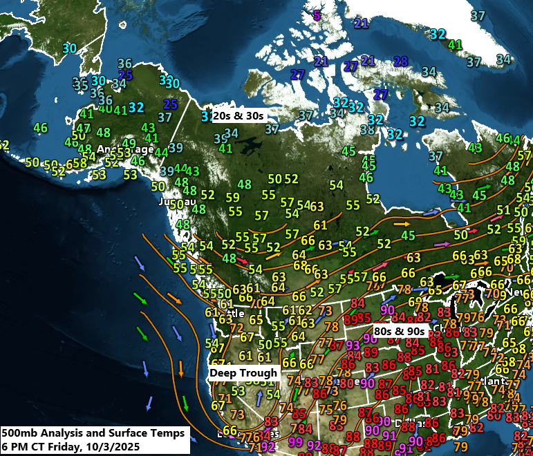
A deep trough over the western U.S. is set to bring mountain snow and rain to the lower elevations of the Rockies and northern Plains this weekend. By Sunday, this trough will move northeast into central Canada.
Goes-16 water vapor loop ending 5:40 PM CT Friday, October 3, 2025.

This weekend, two key areas are expected to see higher precipitation totals. The first will be over the Dakotas and into far northwest Minnesota, where rain totals could range from 0.50 to over 1 inch by Sunday evening.
The second area might include parts of southern Minnesota and Iowa, stretching into southwest and central Wisconsin, with possible rainfall of up to half an inch, primarily on Sunday afternoon and evening.
This leaves the area in between, including much of northeast Minnesota, the Twin Ports, and northwest Wisconsin, with significantly lower rain totals on Sunday based on the current outlook.

The first major winter storm of the season is approaching the higher elevations of Montana and Wyoming, with winter storm warnings and advisories in place for this weekend.

Here’s a look at the European model snowfall by 7 PM Sunday.
In parts of Montana and Wyoming, expect 1 to 6 inches of snow, and over 10 to 12 inches in areas above 7000 feet.

Leave a Reply