Today, Monday, January 26th, is likely to be the 10th consecutive day of below-average temperatures in Duluth, with the last above-average day being January 16th.
Between December 1st and January 25th, Duluth saw 36 days with below-average temperatures and just 20 days with above-average temperatures.
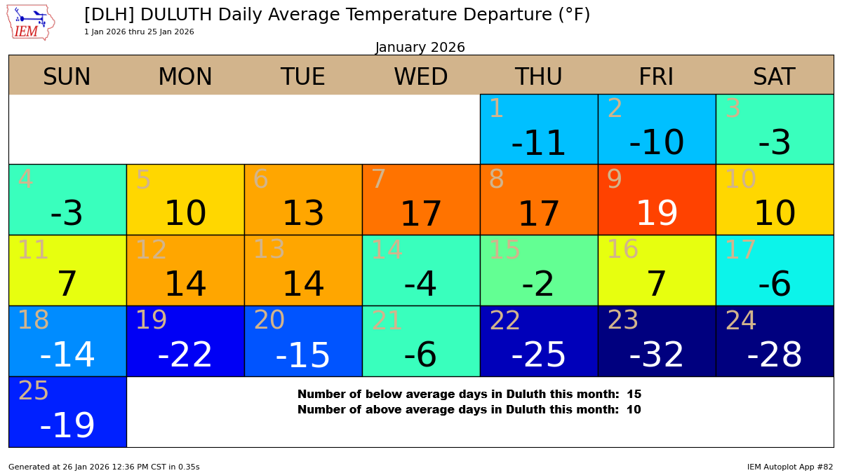
Duluth has seen 14 subzero days this month as of the 26th. With the January average being 15, it’s clear we’ll surpass that very soon.
Note: In January 2025, Duluth had 14 nights of below-zero temperatures.
It was another bitterly cold morning in the Northland.
While we didn’t see as many temperatures dipping into the -30s like in recent days, it was still frigid, with readings ranging from the teens to 20s below zero.
These are some of the lowest temperatures recorded on Monday morning.
- Brimson, MN: -31
- Glidden, WI: -30
- Winton, MN: -29
- Embarrass, MN: -29
- Mountain Iron, MN: -28
- Eveleth, MN: -28
- Pine River, MN: -26
- Ely, MN: -26
- Cable, WI: -26
- Littlefork, MN: -25
On Monday morning, the official low in Duluth was -20 degrees, with Superior Airport hitting -18 degrees and Duluth Sky Harbor Airport recording -17 degrees.
Note: In 4 of the last 5 mornings, Duluth has seen lows of -20 degrees or colder, with the chilliest being -29 degrees on January 23rd.

Over the past week, arctic air has made an impressive sweep across much of the U.S., sparing only the far south and parts of the southwest, where temperatures have stayed near or above average.
The green, blue, and purple areas on the map show where average temperatures over the past week have been between 5 and more than 20 degrees below normal.
Note: Between January 19 and 25, 2026, Duluth went through an extreme cold snap, with temperatures averaging 20.7 degrees below the norm.
Even though we haven’t set any low temperature records during this cold snap in Duluth, it’s still been pretty impressive given how long it’s lasted.

Over 40% of the Great Lakes is now covered in ice, thanks to the recent blast of Arctic air.

Ice coverage on Lake Superior has jumped lately, going from about 5% on January 1st to around 30% by January 25th, which is pretty normal for this time of year.
Lake Superior’s ice coverage usually peaks at around 45–50% between mid-February and early March.

Leave a Reply