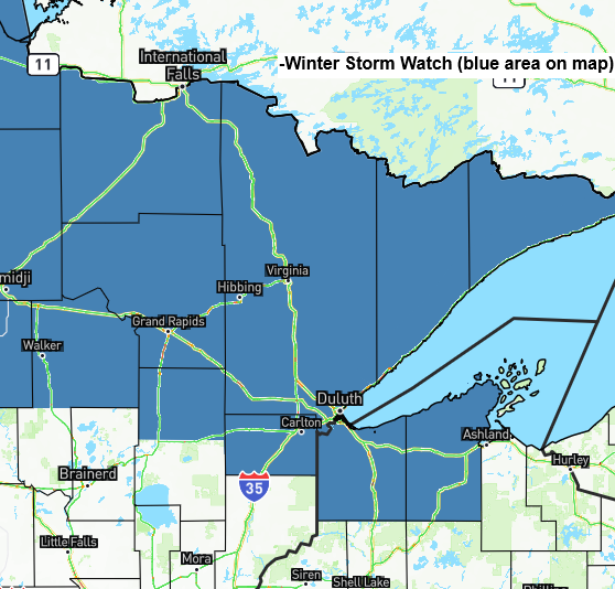
A winter storm watch has been issued for northern and northeastern Minnesota, including Duluth, and far northwestern Wisconsin, from Tuesday night through early Thursday morning as a midweek storm approaches.

Timing: Patchy drizzle and freezing drizzle may develop in Duluth Tuesday afternoon, with snow becoming more likely by Tuesday evening and continuing overnight. Snow will persist from Wednesday into Thursday morning, with the heaviest snowfall expected late Tuesday night through about mid-morning Wednesday.
A look at the top three single-day snowfall totals from the 2025-2026 snow season in Duluth.
- 7.1 inches on November 25th
- 5.3 inches on November 29th
- 4.6 inches on January 16th
Note: Duluth is currently 20.1 inches below its normal snowfall for the 2025-2026 season, yet the 39.8 inches so far is almost identical to the 39.9 inches recorded by February 15th last season.
…Snowfall Forecast…
I’ll be fine-tuning the ranges over the next 24 hours, but here’s my current estimate for snow totals from Tuesday night through early Thursday morning.
Duluth area: 6 to 11 inches
The North Shore, including Two Harbors, could see 11 to 16 inches of snow, while areas from Silver Bay to Grand Marais could see 16 to 23 inches.
Generally, 3 to 6 inches of snow are expected across much of northern Minnesota and far northwest Wisconsin.
Look for 1 to 3 inches of snow from Brainerd and Aitkin, stretching east to Hinckley and into much of northwest Wisconsin.
It’s interesting to see the differences between the Euro and Euro AI models with this system, as the AI shows the low staying farther south and predicting much higher snow totals in Duluth, while the Euro model keeps the low farther north with slightly lower totals. The GFS model has been consistent, aligning with the Euro AI model for quite a significant snow event in Duluth.

…Strong winds and blizzard to near-blizzard conditions are possible along the North Shore of Lake Superior from late Tuesday night through Wednesday…
Strong east to northeast winds are expected to develop near Lake Superior, including Duluth, on Tuesday, continuing through Wednesday and into Thursday morning farther up the North Shore. Gusts could reach 30 to 50 mph, with the most intense winds likely from Tuesday afternoon into Wednesday.
Note: Winds in the Twin Ports area are expected to ease by Wednesday night.
Euro model wind gust forecast valid 12 PM Tuesday to 12 PM Thursday.

A blizzard is all about wind and visibility, not just how much snow falls. It means winds over 35 mph, visibility of a quarter mile or less, and falling or blowing snow, all continuing for at least three hours.
That said, areas northeast of Duluth along the North Shore seem most likely to meet blizzard criteria late Tuesday night into Wednesday, though Duluth itself still has a chance—just not as high as farther up the shore.

This is the forecast map for 6 a.m. on Wednesday, February 18, 2026.
There are two low-pressure centers, one over southeast North Dakota and the other over southern Minnesota. These systems will drift slowly eastward and possibly northeastward through early Thursday.
One difference showing up in the computer models is the position of the northernmost boundary, stretching from southeast North Dakota toward Duluth and across far northern Wisconsin. If this boundary stays a bit farther south than expected, snow and strong winds could linger in Duluth into early Thursday morning. But if it shifts a little farther north, most of the snow and strong winds will taper off by Wednesday afternoon.

The lack of major snow events in the Northland this winter has been due to a persistent northwest flow and frequent clipper systems. But the pattern is changing, with a more consistent trough bringing cooler weather to the western U.S. and warmer conditions east of the Rockies. This setup will create an occasional active southwest flow aloft across the upper Midwest, carrying systems through our area in the coming weeks.

…Gales on Lake Superior…
A gale watch is in effect from Tuesday afternoon through Wednesday evening for the areas marked in pink, with the possibility of a northeast to east gale. There’s also a chance of storm-force wind gusts up to 50 knots along the North Shore of Lake Superior from Tuesday night into Wednesday morning, and a storm watch might be issued.

…Dense Fog tonight near Lake Superior tonight…
This evening, dense fog will drift southwest along the North Shore of Lake Superior, with visibility dropping to a quarter mile or less in some areas.
Note: If visibility doesn’t improve, the dense fog advisory could be extended past its current 10 PM expiration time tonight.

Leave a Reply