The main story is still the potential winter storm expected to roll in around midweek, but it’s worth noting today’s record-breaking warmth in the Northland. Ashland, Brainerd and Hibbing all set new daily high temperature records for February 14th, with more details on that coming later in this post.
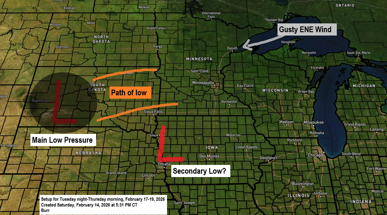
Here’s the latest on the midweek weather system: a low-pressure area, possibly with multiple centers, is set to move into the western High Plains and northern Plains on Tuesday before heading east. While its exact path is still a bit uncertain, it’s looking likely that much of northeast Minnesota and northwest Wisconsin will get accumulating snow from late Tuesday night through early Thursday morning, with the heaviest snowfall expected on Wednesday.
If this system shifts farther north, the chances of a rain/snow mix will go up, especially in parts of northwest Wisconsin and eastern Minnesota, which could mean lower snow totals there. Definitely something to watch over the next few days.
Temperatures in the Duluth area look cold enough for this to be mostly a snow event. However, if the low shifts farther north, we could see a mix extending up to Duluth.
Snow is expected to start in Duluth Tuesday evening and continue through Wednesday evening, with the heaviest snowfall likely early Wednesday morning into midmorning. I plan to share my first snowfall forecast for this event on Sunday, but if I had to guess now, I’d estimate Duluth could get between 5 and 8 inches of snow.
Near Lake Superior, the wind could make for quite a story, with east to northeast gusts of 30 to nearly 50 mph expected from Tuesday afternoon through Wednesday evening. These powerful winds might bring periods of near whiteout conditions from falling and blowing snow, and possibly even near blizzard conditions along the North Shore on Wednesday.
There’s some ice covering parts of Lake Superior (the white areas that stay still in the loop), but there’s also plenty of open water (the blue areas), while moving white areas in the loop show the clouds drifting across.
Note: As of February 13, 2026, about 53% of Lake Superior was covered in ice.
From Tuesday night to early Thursday morning, easterly winds could bring some lake and terrain-enhanced snow near Lake Superior, especially along the North Shore. The lake effect might be limited by 850mb temperatures, which are expected to be around -5 to -10°C on Wednesday and Thursday, but that could still be cold enough for a bit of a snow boost midweek along the North Shore.
Goes-19 visible satellite loop from Saturday, February 14, 2026.

This afternoon, we experienced a common spring phenomenon in Duluth: cooler temperatures by the lake.
This afternoon, temperatures ranged from the upper 40s to low 50s farther inland from Lake Superior, while closer to the lake, they were in the upper 20s and 30s.
This afternoon, dense fog lingered in the Canal Park area of Duluth, while other parts of the city, which were foggy earlier, cleared up to reveal plenty of sunshine.

Here’s a look at the high temperatures, departures, and records for February 14, 2026.
***=New daily high temperature set
Ashland, WI
High: 53***
Departure: 27 degrees above normal
Record high: 48 set in 2018
Brainerd, MN
High: 50***
Departure: 24 degrees above normal
Record high: 45 set in 1967 and 2002
Hibbing, MN
High: 48***
Departure: 26 degrees above normal
Record high: 45 set in 1999 and 2018
Duluth, MN
High: 47
Departure: 23 degrees above normal
Record high: 48 set in 1882
International Falls, MN
High: 43
Departure: 22 degrees above normal
Record high: 48 set in 2018
Ashland, Brainerd, and Hibbing all broke their daily high temperature records today for February 14th.
Note: Before today, the last time temperatures hit 50 degrees or warmer in Brainerd and Ashland was November 24, 2025.
Record Highs for February 15
- Ashland: 49 set in 1931
- Brainerd: 48 set in 1921
- Duluth: 46 set in 1931
- International Falls: 46 set in 1981
- Hibbing: 44 set in 1981
Leave a Reply