An active weather pattern is expected next week, with a key period of interest from late Tuesday night through early Thursday morning. During this time, a broad low-pressure system is forecast to move out of the northern Rockies and western High Plains region.
Colder air brought in by northeast winds is set to move into the Northland on Tuesday, while moisture from the Pacific, and possibly the Gulf, will push north and east Tuesday night, lingering into Wednesday.
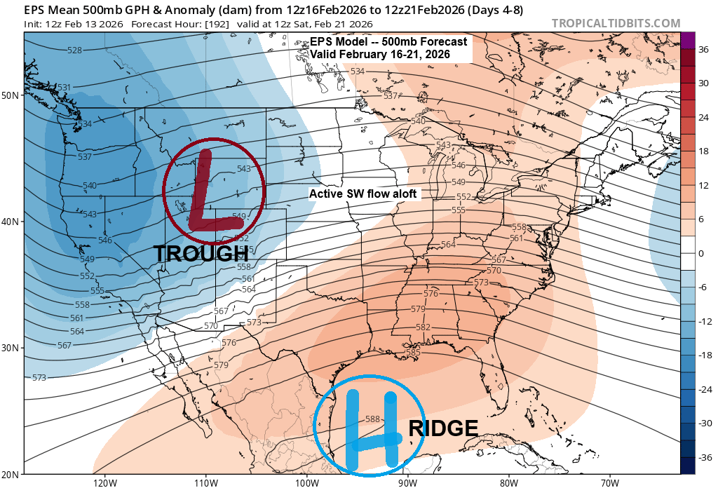
Lately, computer models have been showing a trend toward a colder system for midweek in our area, which means snow is looking like the most likely type of precipitation at this point.
The system’s path could still drift north, bringing a mix of snow and rain to parts of the area, or slide farther south, lessening the impact in some parts of the Northland. There’s still a lot to keep an eye on in the coming days, but it’s looking more and more likely that much of the Northland will feel the effects by mid-next week.

Strong northeast winds could develop in Duluth and other areas near Lake Superior from Tuesday afternoon into Wednesday, with gusts possibly reaching 25-30 mph or higher.
Northeasterly winds could bring some lake and terrain-enhanced snow near Lake Superior, particularly along the North Shore. Gusty winds may also cause areas of blowing snow.
Euro model wind gust forecast valid 12 PM Tuesday to 6 AM Thursday.

…Mild weather continues…
Today was the warmest day of the year so far, with temperatures climbing into the 40s and even the 50s in some areas. Similar highs are expected over the weekend, though how quickly any fog and low clouds clear will determine just how warm it gets. If they stick around, it’ll be a bit cooler.
Here’s a look at the high temperatures, records, and departures for February 13. While no new record highs were set today, Ashland and Duluth came within a degree of matching their daily record high temperatures.
Ashland, WI
High: 48
Departure: 22 degrees above normal
Record high: 49 set in 1976
Hibbing, MN
High: 47
Departure: 25 degrees above normal
Record high: 49 set in 2011
Duluth, MN
High: 46
Departure: 22 degrees above normal
Record high: 47 set in 1947
Brainerd, MN
High: 45
Departure: 19 degrees above normal
Record high: 49 set in 1947, 1976 and 2011
International Falls, MN
High: 40
Departure: 19 degrees above normal
Record high: 46 set in 2011

Temperatures in the Twin Ports climbed into the mid-40s to low-50s today.
In Duluth, today’s high of 46 degrees on February 13, 2026, was the warmest since November 24, 2025, when temperatures reached 53 degrees.

…Record highs for February 14…
- Ashland: 48 set in 2018
- Duluth: 48 set in 1882
- International Falls: 48 set in 2018
- Brainerd: 45 set in 1967 and 2002
- Hibbing: 45 set in 1999 and 2018
Saturday’s forecast calls for highs in the 50s and even some 60s across southern Minnesota, while areas farther north will see 30s and 40s, with a few spots possibly reaching the 50s.

Leave a Reply