Overnight and early this morning, scattered downpours and thunderstorms swept through parts of northeast Minnesota and northwest Wisconsin before moving out over Lake Superior and northern Lake Michigan. Some of those storms had cloud tops reaching around 50,000 feet, which is pretty impressive for this time of day. With elevated CAPE values near 3000 J/kg, though, it’s not too surprising to see such towering clouds so early.
Duluth saw just over a quarter inch of rain at the airport, with 0.31 inches recorded from the overnight showers and storms.
Goes-19 infrared satellite loop ending 7:11 AM CT Monday, June 29, 2026.

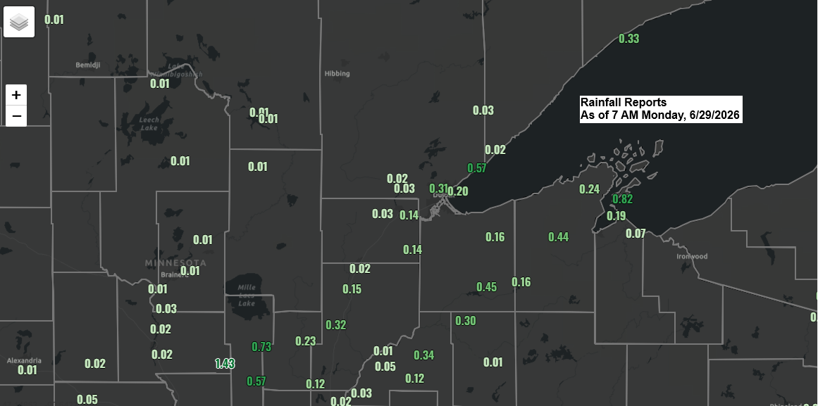
Rainfall totals from late Sunday evening through early Monday morning, June 28-29, 2026, as of 7 a.m.
Solon Springs, WI: 0.45″
Danbury, WI: 0.34″
Duluth Airport: 0.31″
Minong, WI: 0.30″
Bayfield, WI: 0.24″
French River, MN: 0.24″
Esko, MN: 0.22″
Poplar, WI: 0.16″
Kettle River, MN: 0.15″
Maple, WI: 0.15″
Pleasant Valley, MN: 0.14″
Siren, WI: 0.12″
Superior Airport: 0.09″
Grantsburg, WI: 0.05″
Saginaw, MN: 0.03″
Ashland, WI: 0.03″
Here’s a look at the MRMS radar loop showing the showers and thunderstorms over parts of Lake Superior and northern Lake Michigan early this morning. In their wake, we’re seeing some additional showers pop up over parts of the Northland with movement to the northeast.
Radar loop ends 7:22 AM Monday, June 29, 2026.
Confidence in the forecast is low for today and tonight, but warmer air higher up in the atmosphere is expected to move into much of the Northland, pushing 700mb temperatures to around +13 to +16°C. This could shift the thunderstorm and potential severe weather threat to far northern Minnesota during the afternoon and early evening, with the possibility of large hail and damaging winds.
This evening, after 7 or 8 PM, there’s a chance the cap could break down quickly. If that happens, thunderstorms might fire up farther south in central Minnesota and then race through the Northland from mid to late evening into early Tuesday morning, bringing the risk of strong winds and hail.
Duluth area: Scattered showers and a chance of thunderstorms before noon will give way to mostly dry weather this afternoon and early evening, with storm chances picking up again after 7 or 8 PM. Fog is likely to linger near Lake Superior for much of the day. Temperatures will stay in the 50s within about 15 miles of the lake, climbing into the 60s and 70s farther inland.

Leave a Reply