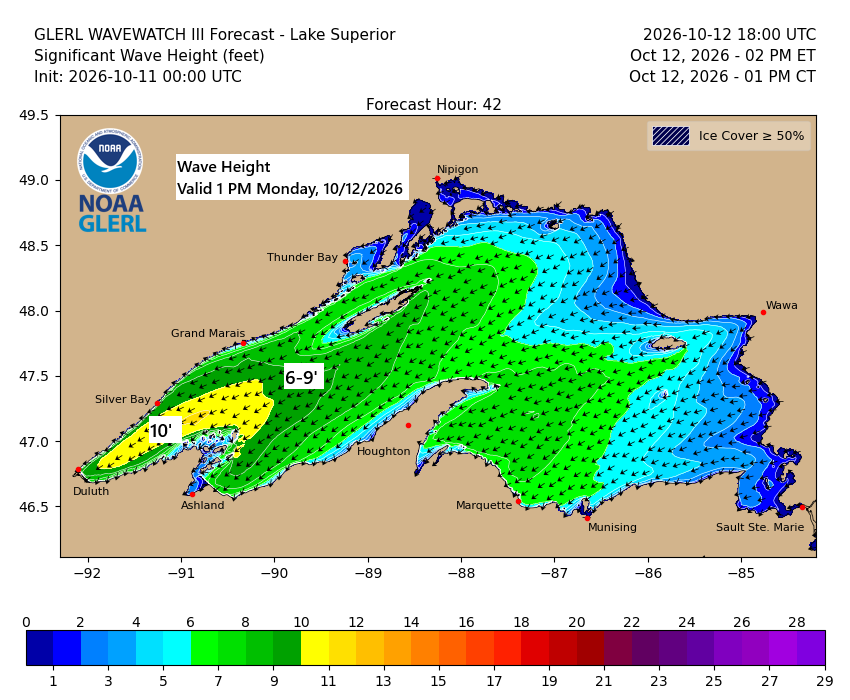
…Gales on western Lake Superior Monday…
East to northeast winds will pick up over western Lake Superior on Monday, with gusts hitting 25 to 45 mph. Waves are expected to build to 5 to 10 feet, with the biggest swells likely from late morning through mid-evening.

In Duluth, northeast winds are expected to pick up quickly late tonight between 10 PM and midnight, with strong gusts lasting through late Monday evening. Gusts of 25 to 45 mph are anticipated in the Twin Ports area.

Monday afternoon temperatures will be in the 40s and 50s across much of northeast Minnesota and northwest Wisconsin, while warmer 60s and even 70s are possible further south, from Hinckley and Pine City east to Hayward and Winter.

Was today, October 11th, the last time Duluth will hit 70 degrees until next spring? On average, the final 70-degree day here lands on October 10th (based on the 1874–2025 climate period), with the latest on record being November 9th in 1999.
The last 70-degree days in Duluth, dating back to 2020.
2020: November 6
2021: October 19
2022: November 2
2023: October 3
2024: October 21
2025: October 5
Today brings a big temperature swing, with Montana seeing highs in the 30s and 40s, while parts of the central Plains and upper Midwest climb into the 80s.

This afternoon, temperatures in our area varied from 49 degrees in Grand Forks, ND to 80 degrees in Duluth, MN.

Showers will continue tonight in far northern Minnesota, with patchy drizzle, fog, and additional light lake effect showers expected to develop near Lake Superior overnight, lingering into Monday.
Another round of showers is expected to move through the area late Monday afternoon into the evening, with a chance of an isolated thunderstorm.
By early Tuesday morning, rainfall totals between 0.1 and 0.25 inches are possible across much of northeast Minnesota and northwest Wisconsin, with some areas seeing higher amounts.

Snow, shown in blue on the map, continues to fall over parts of the northern Rockies today, while areas of rain appear in green. This moisture comes from the remnants of tropical storm Rachel.
MRMS radar loop from Sunday, October 11, 2026, running from 1:18 to 4:18 PM CT.
Rachel over the western U.S. and Isaias over the eastern U.S., two tropical systems or their remnants, are on display today.
Goes-East water vapor loop from Sunday, October 11, 2026, loop time 4:25 AM to 4:15 PM CT.
Leave a Reply