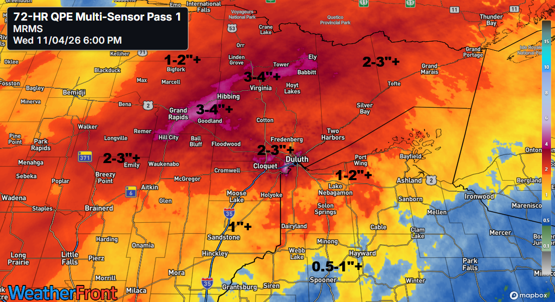
Only four days into November 2026, Hibbing, Minnesota has already broken the record for the wettest November, with 4.04 inches of precipitation recorded by 5 PM on the 4th. The previous record was 3.58 inches, set back in 1977.
Here’s a look at rainfall totals across the Northland from November 2, 2026, to 5 PM on November 4, 2026.
- 12 N Two Harbors, MN: 5.50″
- Keewatin, MN: 5.35″
- Winton, MN: 4.63″
- Grand Rapids, MN: 4.50″
- Hermantown, MN: 4.45″
- Babbitt, MN: 4.24″
- Hibbing, MN: 4.04″
- Hill City, MN: 3.93″
- Seagull Lake, MN: 3.88″
- Aurora, MN: 3.83″
- Brainerd, MN: 3.66″
- Beaver Bay, MN: 3.62″
- Palmers, MN: 3.55″
- Meadowlands, MN: 3.45″
- Ely, MN: 3.43″
- Hog Creek, MN: 3.38″
- Buyck, MN: 3.33″
- Lutsen, MN: 3.32″
- Floodwood, MN: 3.32″
- Burnett, MN: 3.31″
- Pine River, MN: 3.19″
- Walker, MN: 3.11″
- Crosslake, MN: 3.07″
- Grand Marais, MN: 3.05″
- French River, MN: 3.03″
- Isabella, MN: 2.96″
- Saginaw, MN: 2.89″
- Two Harbors, MN: 2.86″
- Duluth Airport: 2.82″
- Duluth Sky Harbor Airport: 2.81″
- Superior, WI: 2.80″
- Side Lake, MN: 2.76″
- Longville, MN: 2.76″
- Brimson, MN: 2.60″
- Cass Lake, MN: 2.58″
- Wright, MN: 2.26″
- Federal Dam, MN: 2.22″
- McGregor, MN: 2.17″
- Solon Springs, WI: 2.09″
- Northome, MN: 2.09″
- Orr, MN: 2.05″
- Littlefork, MN: 2.04″
- Bigfork, MN: 2.03″
- Pleasant Valley, MN: 2.03″
- Esko, MN: 1.94″
- Scanlon, MN: 1.89″
- Poplar, WI: 1.89″
- Webb Lake, WI: 1.87″
- Aitkin, MN: 1.86″
- International Falls, MN: 1.81″
- Minong, WI: 1.79″
- Hinckley, MN: 1.76″
- Ashland, WI: 1.72″
- Willow River, MN: 1.66″
- Danbury, WI: 1.62″
- Maple, WI: 1.49″
- Clam Lake, WI: 1.49″
- Odanah, WI: 1.46″
- Glidden, WI: 1.44″
- Hayward, WI: 1.36″
- Siren, WI: 1.35″
- Winter, WI: 1.34″
- Earl, WI: 1.30″
- Grantsburg, WI: 1.16″
- Oulu, WI: 1.14″
- Shell Lake, WI: 0.92″
- Spooner, WI: 0.76″
On Tuesday, November 3, 2026, Duluth, MN broke its daily precipitation record with 0.63 inches of rain. The previous wettest November 3rd was 0.56 inches, recorded in 1919.
Note: International Falls, Hibbing, and Brainerd set new precipitation records today, November 4, 2026. I’ll share those records in Thursday’s post once the final rainfall totals for the day are confirmed later this evening.
…Cooler/Windy Weather on the way…
After this stretch of rain, a burst of colder, more typical seasonal air will move into the Northland on Thursday and Friday, with temperatures at 850mb dropping to between -3 and -8°C by Thursday evening.
Windy conditions are expected tonight and Thursday, with northerly gusts ranging from 15 to 30 mph. Stronger gusts of 35 to 50 mph are possible along parts of the North Shore of Lake Superior later tonight into Thursday morning.

With highs only in the 30s to lower 40s Thursday and Friday, and overnight lows dipping into the 20s and 30s, the Northland will get a taste of more seasonable November weather after the unusually mild fall conditions we’ve enjoyed. The cooler stretch will be brief, however, as temperatures moderate this weekend and early next week, with afternoon temperatures returning to the 50s across much of the region. For perspective, normal early November temperatures feature highs in the lower 40s and lows ranging from the lower to upper 20s.
…Departing Storm…
Low pressure is finally moving away from the Northland this evening, heading east across Lake Superior. Dry conditions will settle into northeast Minnesota and northwest Wisconsin over the next few days as the system clears out tonight.

Before a drier pattern sets in, we still need to deal with the backside of this system, as rain will keep moving southeast across northeast Minnesota and northwest Wisconsin tonight, gradually tapering off from northwest to southeast overnight and into Thursday morning.
For Duluth: The rain will ease up later tonight between midnight and 2 AM.
Radar loop from 11:44 PM CT Tuesday, November 3, 2026, to 5:43 PM CT Wednesday, November 4, 2026.
HRRR model forecast through 10 AM Thursday — Additional rainfall totals.

A closed 500mb low near Minneapolis, MN this afternoon, along with a mid to upper-level trough, will move northeast and leave the Northland by Thursday morning.

Goes-West water vapor loop from Wednesday, November 4, 2026, loop time ends 5:35 PM CT.
Leave a Reply