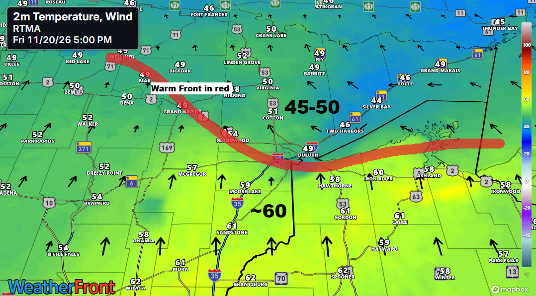
Early this evening, a warm front is lifting north across northeast Minnesota. Temperatures south of the front range from the mid-50s to low 60s, while north of the front they are in the mid-40s to around 50. Patchy drizzle and light fog are also present, reducing visibility to approximately 2 to 5 miles near and north of the frontal boundary.
In Duluth, temperatures are forecasted to gradually climb overnight to a range of 51 to 56 degrees. This mild air mass is expected to linger through Saturday morning, with a modest drop in temperatures likely by Saturday afternoon.
Expect scattered showers across the Northland tonight through Saturday morning, with a possibility of brief, heavier downpours early to mid-morning on Saturday as a cold front moves eastward through the region.
HRRR model simulated radar forecast through 10 AM Saturday.
Here’s an overview of the forecasted rainfall totals through Saturday afternoon according to the blended model data.

Record Highs Fall Across the Region: Records Set or Tied as of 5 PM Friday, November 20, 2026.
Ashland, WI
New record high: 64 degrees
Old record: 62 degrees set in 1925, 1930 and 1982
Hibbing, MN
Record high tied: 52 degrees. This record was previously set in 1982
Note that International Falls could also tie or break its daily high temperature record for November 20th, which stands at 50°F, set in 1963.
Thursday brought yet another round of record-high minimum temperatures across the Northland.
Here are the new records set or matched on November 19
Ashland, WI
New record warm low: 43 degrees
Previous record: 41 degrees set in 2024
International Falls, MN
New record warm low: 39 degrees
Previous record: 38 degrees set in 1982
Duluth, MN
Tied record warm low: 39 degrees. Record was previously set in 1982 and in 1930.
…Snow bursts/Colder air arrives Sunday…
On Sunday, a strong 500mb vorticity maximum will move east-southeast from eastern North Dakota. This system is expected to trigger snow showers across the Northland, with rain or a wintry mix more likely near Lake Superior.
Euro model 500mb forecast valid 6 AM Sunday to 6 AM Monday.
Snow – blue
Rain – green
HRRR model simulated radar forecast valid 6 AM to Noon Sunday.
Snowfall of up to an inch is possible Sunday in parts of northern Minnesota and Sunday night in areas of northern Wisconsin.

A brief but notably chilly airmass will move into the Northland early next week, with 850mb temperatures dropping to around -10 to -15°C. This should keep daytime highs on Monday in the 20s to lower 30s, which is more typical for late November in this region. However, as has been the pattern this month, this cold snap is expected to be short-lived.

The system crossing the Upper Midwest tonight is clearly visible on water vapor imagery, while Sunday’s disturbance is progressing southeastward across Alberta, Canada.
Goes-East water vapor loop from Friday, November 20, 2026, ending at 6:20 PM CT.

Leave a Reply