Just some thoughts before we get into the forecast, but I think the writing may already be on the wall regarding the type of winter we’re headed into across the Northland. While November isn’t officially a winter month, it’s often one of our more volatile weather months, capable of producing everything from major snowstorms to subzero cold. Instead, we’ve spent much of the month running above normal, a trend that could be offering an early glimpse of the pattern we’ll be dealing with as meteorological winter approaches.
Consider how temperatures have behaved in Duluth through November 19th. Only three days have been colder than average, and those departures were minimal, just 1° to 3° below normal. That’s hardly what you’d call a sustained shot of cold air.
Meanwhile, 15 days have been warmer than average, with some days running an incredible 15° to 20° above normal. That’s a stark contrast. When the cool days are only slightly below average, but the warm days are repeatedly blowing past normal by double digits, it’s easy to see which side is winning. The warm pattern hasn’t just been present this month, it’s been overwhelmingly dominant.

What I’m getting at is that while we’ll likely see a few shots of colder air over the next several weeks, including one arriving this Sunday, the overall pattern continues to favor warmth. At this point, I don’t see much evidence suggesting a significant change to that regime anytime soon.
As for snow, model guidance remains largely devoid of any consistent signals pointing to a major winter storm affecting the Northland over at least the next seven days. In fact, if Duluth fails to record at least 0.1 inches of snowfall on Sunday (November 22), we’ll be in a strong position to challenge the record for the latest first measurable snowfall of the season. That record currently stands at November 26, set in 2004.
…Onto the Forecast…
While Wednesday’s storm system has exited to the northeast, gusty winds remained in its wake today. Those breezy conditions will continue through Friday and Saturday as another low-pressure system takes a similar path, tracking northeast across the Dakotas before reaching Ontario on Saturday.
Precipitation with this system should remain fairly limited locally Friday and Saturday, though scattered showers are possible as a warm front lifts north from southern Minnesota on Friday, followed by a cold front sweeping east out of western Minnesota Friday night.
Rainfall amounts are expected to range from 0.01 to 0.20 inches across northeast Minnesota and northwest Wisconsin through Saturday afternoon.
Blend of Models forecast below

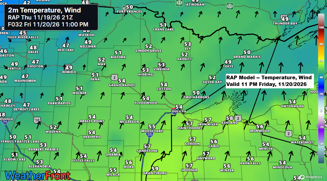
Temperatures will be the primary story with this system. Strong warm advection behind the northward-moving warm front is expected to push temperatures well into the 50s across much of the Northland Friday night. This anomalously mild air mass should remain in place through at least Saturday morning before a trailing cold front sweeps east across the region Saturday afternoon, initiating a sharp west-to-east temperature decline.
From a climatological standpoint, temperatures in the 50s Friday night would be exceptionally mild for late November. Normal overnight lows across the region this time of year generally range from around 14°F to 23°F, placing forecast temperatures more than 30 degrees above average in some locations.
It’s certainly possible that some of the record highs listed below could be in jeopardy on Friday.
…Record High Temperatures for November 20th…
Ashland, WI: 62 set in 1925, 1930 and 1982
Brainerd, MN: 61 set in 1917
Duluth, MN: 61 set in 1925
Hibbing, MN: 52 set in 1982
International Falls, MN: 50 set in 1963
RAP model temperature and wind valid 12 PM Friday to 12 PM Saturday.
A southwesterly low-level jet will intensify Friday afternoon into the evening, aiding the passage of a warm front through our region.

Following the passage of a cold front on Saturday, a colder, more seasonable airmass will arrive on Sunday. As a trough moves across the region, with sufficient lift and lingering moisture, we can expect snow showers in parts of the Northland, with rain showers or a mix closer to Lake Superior.
Not expecting widespread snow accumulation on Sunday, but some areas, particularly in northern Minnesota, could see a light coating of up to an inch. Similarly, parts of northwest Wisconsin, especially near the South Shore, may experience lake-effect snow showers developing Sunday night into Monday.

Here’s a look at the peak wind gusts from Thursday.
- Houghton, MI: 59 mph
- Rock of Ages, MI: 53 mph
- Duluth Airport: 41 mph
- Silver Bay, MN: 40 mph
- Ashland, WI: 40 mph
- Thompson Hill (Duluth) 39 mph
- Duluth Sky Harbor Airport: 38 mph
- Port Wing, WI: 37 mph

Northland saw record warm lows on November 18, 2026.
Brainerd, MN:
New record warm low: 46 degrees
Previous record: 43 degrees set in 2012
Duluth, MN
New record warm low: 44 degrees
Previous record: 43 degrees set in 1953
Hibbing, MN
New record warm low: 44 degrees
Previous record: 38 degrees set in 1953
International Falls, MN
New record warm low: 43 degrees
Previous record: 34 degrees set in 2015
November 2026 temperature anomalies across the contiguous U.S. favor widespread above-average warmth, with the strongest positive departures from normal highlighted by the darker colors and pink shades on the map.
In northeast Minnesota and northwest Wisconsin, average temperatures through November 18 are approximately 9 to 11 degrees above normal, keeping November 2026 on track to become the warmest on record.

A significant weather system is impacting the western United States today, while the system that traversed the Northland earlier has already progressed to the Ontario-Quebec border this evening.
Goes-West water vapor loop from Thursday, November 19, 2026. Loop time ends 5:45 PM CT.
And we can’t forget Florida, where heavy rainfall over the past few days has significantly impacted the eastern regions. MRMS estimates indicate 3–6 inches of rain, with the blue-shaded areas showing 10 inches or more over the 48 hours ending at 5 PM CT on Thursday, November 19, 2026.

Leave a Reply