Tag: severe potential
-

Plains Storm Line May Race Into the Northland Monday, Bringing an Isolated Wind and Hail Risk
New trends are starting to emerge in the model guidance from Sunday evening for Monday. There’s a chance a line of thunderstorms could form over western Nebraska or western South Dakota overnight, then race northeast, possibly impacting parts of north-central and northeast Minnesota from mid to late Monday morning into…
-

Flood Watch issued for parts of the Northland; Rounds of showers and thunderstorms through Monday night with a threat for heavy rain (flooding) and a risk for some strong-severe storms
10:49 AM Sunday, May 29, 2022 Flood Watch in effect through Tuesday morning for parts of north-central and northeast Minnesota including the cities of Pine River, International Falls, Ely, Brainerd, Hill City, Grand Rapids, Walker, and Bigfork. Flash flooding caused by excessive rainfall possible. Several rounds of thunderstorms are expected…
-

Mesoscale Discussion issued for parts of the Northland – Watch likely!
5:21 PM Friday – Storm Prediction Center has outlined much of western and central Minnesota in a Mesoscale Discussion with severe weather likely, and a 95% chance that a watch will be issued in and near the outlined area on the map over the next few hours. Link to technical…
-
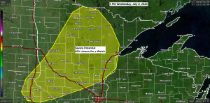
Severe Thunderstorm potential increasing across parts of the Northland
A Mesoscale Disccusion has been issued by the Storm Prediction Center for much of central and northern Minnesota (yellow area on map) Severe Potential…There is a 60% chance that a watch will be issued over the next few hours inside or very close to the yellow outlined area on the…