Tag: long range forecsat
-

A few light showers/sprinkles possible Thursday; Highs in the 50s to lower 60s through early next week; A more active pattern possible mid/late next week with rain and snow chances
5:55 PM Wednesday, October 26, 2022 An upper-level disturbance lifting ENE out of the western High Plains is bringing some rain to parts of Nebraska and far southern South Dakota this afternoon. Some of this rain will eventually affect portions of western and southern Minnesota late tonight into Thursday morning,…
-
Scattered showers and t-storms with heavy downpours tonight; Windy through Monday; Cooler (more seasonable) temperatures arrive on Tuesday followed by another warming trend later this week
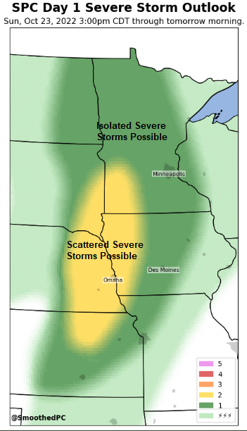
5:30 PM Sunday, October 23, 2022 The atmosphere continues to destabilize in the Northland this afternoon and this will eventually lead to the development of scattered fast moving showers and thunderstorms from about mid-evening through early Monday morning. Thunderstorms that do develop tonight will have the potential to produce heavy…
-
Breezy and Warmer Tuesday; mainly dry thru this weekend; active weather pattern next week?
A dry weather pattern thru this weekend. One of the warmer days this week in our area will be on Tuesday with highs in the 40s to around 50 across the Northland, but it will be windy on Tuesday as west to southwest winds gust to around 20 to 30…