- A dry weather pattern thru this weekend.
- One of the warmer days this week in our area will be on Tuesday with highs in the 40s to around 50 across the Northland, but it will be windy on Tuesday as west to southwest winds gust to around 20 to 30 mph.
- Daytime highs in the 30s and 40s are then expected Wednesday through Saturday, although it could be a little cooler near Lake Superior as east winds develop mid to late week.
For those that are interested, you can now listen to an audio version of my blog/weather forecasts. I’m not sure yet if I’ll convert every one of my blog posts to audio going forward, or if I’ll just do a few every now and then.
My podcast is currently available on Anchor, Pocket Casts and Spotify
https://anchor.fm/timothy-burr; https://pca.st/f26jvwb8; https://open.spotify.com/show/10SfOGL3mGTxizRVKWFxvh
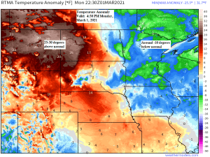
A chilly first day of meteorological spring 2021 across the Northland with highs only in the teens to around 20 degrees today, but see those 40s and 50s off to our west? Well those are moving our way for Tuesday, with widespread 40s expected in northeast Minnesota and northwest Wisconsin, and maybe even a shot at 50 degrees for a few locations.

Ice concentration on Lake Superior has decreased significantly from a few weeks ago when Lake Superior was roughly 50% ice covered, but as of March 1st, that amount has dropped to around 11%!
Source: https://weather.cod.edu/

Kind of a neat satellite loop from today showing areas with snow cover (green) while clouds show up as gray colors on the animation below.
Source: https://weather.cod.edu/

A more active weather pattern might develop starting next week as the computer models (GEFS and EPS) are certainly showing a pattern that could help generate a larger/stronger system sometime next week or early in the following week (around March 9-15) it’s way too early to go into detail as to what type/s of precipitation we could see in the Northland since that will depend on storm tracks and temperatures. We could be looking at a decent amount of snow, rain, or a mix of rain and snow, and possibly even some ice. Stay tuned.
The image below shows the first system to keep an eye on, this one is for around March 10th (timing could change) but as you can tell by all the red Ls on the map, there is a ton of uncertainty on where a surface low will be next Wednesday morning per Euro ensemble model. The range is from the western Dakotas to north Texas, to as far east as eastern Missouri and eastern Wisconsin.
Source: https://weathermodels.com/

We shouldn’t get any new snow in Duluth thru this weekend, but things might change a bit as we head through next week.
Euro ensemble model 15-day snowfall forecast for Duluth valid thru March 16th, 2021.

Thanks for reading/listening!
Leave a Reply