Rainfall reports from around the Northland for July 25-26, 2019
Note: Totals listed below are for the 24 hour period ending at 7 AM Friday, July 26.
Source: https://www.weather.gov/dlh/
- Embarrass: 0.78 inch
- Grand Marais: 0.72 inch
- 10 W Gunflint Lake: 0.70 inch
- Brainerd: 0.70 inch
- Babbitt: 0.67 inch
- 25 E Ely: 0.42 inch
- 3 E Orr: 0.41 inch
- 2 E Celina: 0.37 inch
- Kabetogama: 0.27 inch
- Wolfridge ELC: 0.23 inch
- International Falls: 0.19 inch
- Hibbing: 0.13 inch
- Floodwood: 0.11 inch
- 4 E Island Lake: 0.09 inch
- Duluth Airport: 0.06 inch
A perfect example of how scattered the thunderstorms were that hit parts of the Northland Thursday afternoon into Friday morning (see image below)
Note: The 3 white circled areas on the map indicate rainfall totals of a half inch or more, and yes, once again Duluth and Superior missed out on most of the rain with only a few light rain showers hitting the city early Friday morning.

There is a slight risk for severe thunderstorms through early this evening in northeast Minnesota and far northern Wisconsin, the risk area is generally along and east of a line from Orr to Chaffey.
A marginal risk for severe thunderstorms in the dark green shaded area on map.
General thunderstorms in the light green shaded area on map.
Hazards in the slight and marginal risk areas include
- Large hail up to ping pong ball size (1.50 inch)
- Damaging wind gusts to 60 mph
- A tornado or two possible

Goes-16 mid level water vapor satellite loop from Friday morning shows a rather strong upper level system moving east out of southern Manitoba province, this feature combined with a cold front moving east out of west-central Minnesota could help to produce a few showers and thunderstorms in parts of the Northland by late this afternoon.
Source: https://weather.cod.edu

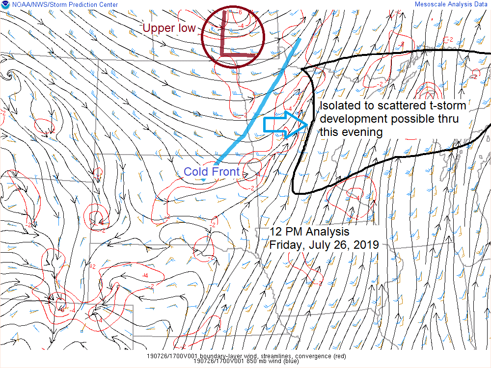
Convergence near a cold front and ahead of an upper low approaching from the W-NW should be enough to get a few thunderstorms to pop up through early this evening.
Thunderstorms that develop will have an unstable airmass to work with including
- CAPE 1000-2000 J/kg
- Strong winds aloft 40-50 knots
- Shear of 30-50 knots
Note: Mid level lapse rates don’t look overly impressive today (less than 7.0 c/km) otherwise the ingredients look favorable for storm organization later today with a few strong to severe thunderstorms, and with the favorable shear in place, isolated supercells could develop.

12z NAM-WRF model radar forecast valid from 2 PM to 10 PM Friday.
This model does show a broken line or two of potentially severe thunderstorms moving east-southeast across parts of northeast Minnesota and northwest Wisconsin later this afternoon into early this evening. Stay Weather Aware!

Tim
Leave a Reply