There is a marginal risk of severe thunderstorms tonight in far northern Minnesota (dark green shaded area on the map below)
The remainder of the Northland is in a general thunderstorm risk for tonight.
Primary threats in the marginal risk area
- Gusty winds
- Hail
Note: All thunderstorms will produce lightning and heavy rainfall.

Radar forecast valid from 7 PM Tuesday to 7 PM Wednesday per 12z HRRR model.
Scattered showers and thunderstorms are possible over most of the Northland through Wednesday morning followed by a few spotty showers for Wednesday afternoon.
Source: https://weathermodels.com

Goes-16 Day Cloud Phase satellite loop from Tuesday, August 6, 2019 (loop time 2 PM to 5:55 PM)
An explosion of strong to severe thunderstorms this afternoon over parts of the Dakotas with other thunderstorms erupting in far northern Minnesota this afternoon, all these storms are developing near a cold front which was over the northern Plains this afternoon.
Source: https://weather.cod.edu

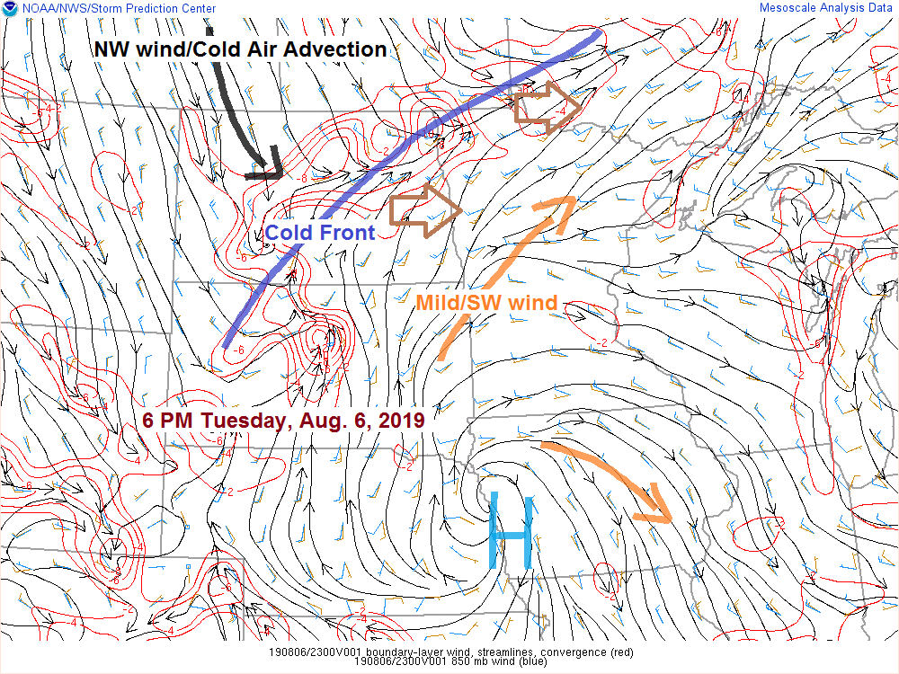
Analysis from 6 PM Tuesday
Source: https://www.spc.noaa.gov

Low temperature forecast for Wednesday morning, August 7. Note: Normal lows on August 7 are in the low to mid 50s. Lows tonight will be ~5 degrees warmer than normal.
Source: https://graphical.weather.gov

High temperature forecast for Wednesday, August 7. Note: Normal highs on August 7 are in the mid to upper 70s, Wednesday’s highs will be within a few degrees of normal.

…Weather Summary…
Scattered showers and thunderstorms possible tonight into Wednesday followed by a few days of dry weather and cooler temperatures.
A cold front will be moving through the Northland tonight into Wednesday morning. Convergence near this front combined with some instability will cause scattered showers and thunderstorms as this front crosses the area.
The threat for severe weather is on the low side tonight with CAPE generally in the 500-1000 J/kg range. Mid level lapse rates aren’t that impressive, and winds aloft remain in the 25 to 35 knots which leads to generally weaker wind shear of 30 knots or less. Storms tonight will be more of a heavy rain producer with lightning, gusty winds and possibly some hail as well in the strongest storms.
It’ll be a mild night with lows in the middle 50s to lower 60s. Partly to mostly cloudy skies are forecast with winds out of the southwest at 5 to 15 mph.
Scattered showers or thunderstorms are possible Wednesday morning in northwest Wisconsin and eastern Minnesota as a cold front moves through those areas.
A few showers are possible Wednesday afternoon as an upper low passes north of the area. Cooler Wednesday with highs mainly in the 70s. Winds will shift to the northwest at 10 to 20 mph.
Thursday and Friday are shaping up to be very pleasant summer days with seasonable high temps in the 70s with lows Thursday night in the 40s and 50s.
Leave a Reply