More frequent rainfalls in the Twin Ports lately — Nearly 3.00 inches of rain (2.98 inches) at the Duluth Airport in roughly the last two weeks (July 26 through August 7) Note: Normal rainfall from 7/26 to 8/7 is 1.45 inches.
Rainfall total for August is running above normal in Duluth (+0.28 inches above normal thru the 7th) but for the summer (since June 1) our rainfall total is still -1.07 inches below normal, not a huge deficit though, and things should even out eventually.
Rainfall Reports from around the Northland
Source: https://mesowest.utah.edu
Note: Totals listed below are from Tuesday, Aug. 6 through 5 PM Wednesday, Aug. 7, 2019.
- Cass Lake, MN: 1.49″
- Walker, MN: 0.69″
- Solon Springs, WI: 0.49″
- Kabetogama, MN: 0.45″
- Grand Rapids, MN: 0.43″
- Duluth Airport: 0.40″
- Moose Lake, MN: 0.38″
- Washburn, WI: 0.38″
- Ashland, WI: 0.34″
- International Falls, MN: 0.32″
- Minong, WI: 0.26″
- Hayward, WI: 0.26″
- Minong, WI: 0.26″
- Clam Lake, WI: 0.23″
- Littlefork, MN: 0.22″
- Hill City, MN: 0.18″
- Chisholm-Hibbing Airport: 0.16″
- Grand Marais, MN: 0.16″
- Saginaw, MN: 0.16″
- Bigfork, MN: 0.13″
- Silver Bay, MN: 0.10″
- Orr, MN: 0.10″
- Two Harbors, MN: 0.09″
- Siren, WI: 0.08″
- Ely, MN: 0.07″
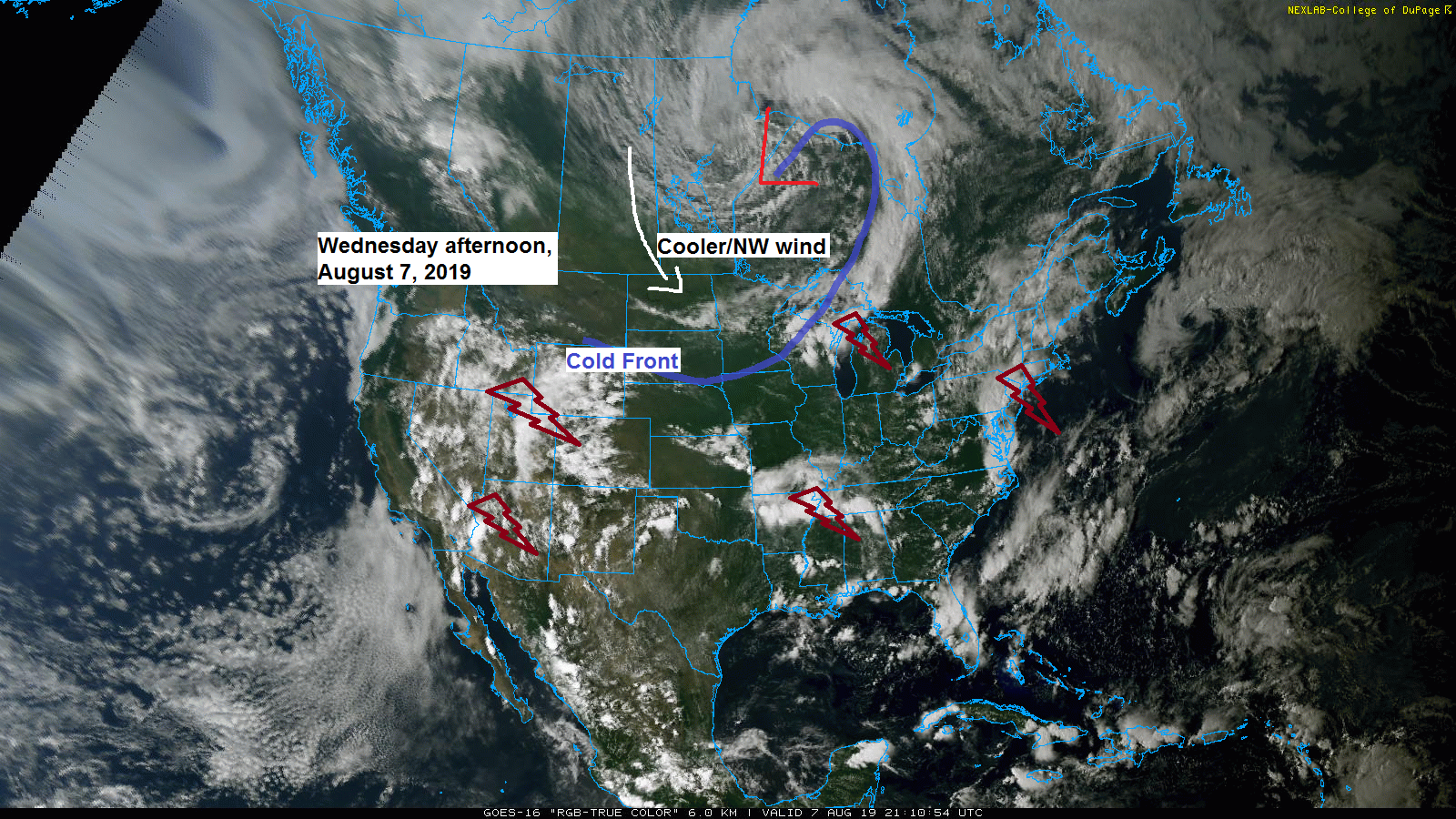
Goes-16 visible satellite image; analysis from Wednesday afternoon, August 7, 2019.
Source: https://weather.cod.edu

Long range computer models keep us in a wetter pattern looking out the next two weeks with potential for 2 inch plus rain totals in the Northland.
Source: https://weathermodels.com

Forecast rainfall totals the next two weeks are forecast to be above normal across much of the northern Plains and upper Midwest per 12 European Ensemble model.

Low temperature forecast for Thursday morning, Aug. 8
Lows tonight ~5 degrees below normal for August 8.
Source: https://graphical.weather.gov

High temperature forecast for Thursday, Aug. 8
Highs Thursday roughly 5 degrees below normal for August 8.

Signs of a pattern change starting to show up in long range model guidance toward mid month. Notice how the northwest flow aloft across the upper Midwest transitions to a west or even southwest flow aloft toward the end of this forecast period (August 23) per 12z GEFS model. Warmth and humidity could surge north again around mid month.
Source: https://www.tropicaltidbits.com/

…Weather Summary…
Breezy northwest winds tonight and Thursday. Cooler and a lot less humid!
Cold front moved through the area last night and today bringing scattered showers and thunderstorms with it. This front is now well south of the Northland late this Wednesday afternoon with northwesterly breezes ushering in a very pleasant airmass which should stick around through Friday.
Isolated showers and thunderstorms will end this evening, and then we should be dry through Friday night.
Lows tonight and Thursday night in the 40s and 50s, highs Thursday in the low to mid 70s, highs Friday ranging from the lower 70s to upper 70s.
Northwest winds gusting 15 to 25 mph tonight into Thursday. Lighter winds on Friday while shifting more to the west.
Weekend weather includes a chance for some rain Saturday and possibly a few lingering showers Sunday, but at the moment Saturday looks like the wetter day of the weekend.
Leave a Reply