Some more rain is on the way! Showers and thunderstorms develop Saturday afternoon in north-central Minnesota (northwest of Duluth)
Chances for showers and a few thunderstorms will increase Saturday night through early Sunday morning in northeast Minnesota and northwest Wisconsin.
Will stay dry in Duluth and Superior during the day Saturday with chances for showers and isolated thunderstorms increasing later Saturday evening or during the overnight.

18z NAM-WRF model radar forecast valid from 1 PM Saturday to 1 PM Sunday. Source: https://weathermodels.com

The next rain event late Saturday into early Sunday is targeting north-central Minnesota for the greatest rainfall amounts which could be in the one half to one inch range with locally higher amounts possible. Lesser amounts of rain are forecast farther south/east including in Duluth and Superior. Source: https://lab.weathermodels.com

24-Hour Rainfall Reports
Source: https://mesowest.utah.edu; https://www.weather.gov/dlh/
Note: Totals listed below are for the 24-hour period from August 15 through 3 PM August 16, 2019.
- Winter, WI: 0.95″
- 4 W Clam Lake, WI: 0.75″
- Butternut, WI: 0.60″
- Hayward, WI: 0.59″
- Spooner, WI: 0.29″
- Ely, MN: 0.25″
- Duluth, MN (Airport) 0.21″
- Moose Lake, MN: 0.19″
- Bigfork, MN: 0.17″
- 3 E Orr, MN: 0.16″
- Isabella, MN: 0.13″
- Ashland, WI: 0.11″
- Minong, WI: 0.09″
- Washburn, WI: 0.08″
- Solon Springs, WI: 0.05″
- Grand Marais, MN: 0.02″
Low temperature forecast for Saturday morning, August 17. Source: https://graphical.weather.gov

High temperature forecast for Saturday, August 17.

Some changes have occurred in model guidance for next week with cooler risks returning to the Northland for the middle of next week thanks to an upper low/trough which digs south/east out of Ontario which causes an upper ridge (warm air) to build north into western Canada. This will cause a northwest mid/upper level flow and cooler weather to spill into the upper Midwest and Great Lakes during the middle of next week.
Source: 12z European ensemble model; https://weathermodels.com

Here’s the temperature anomaly forecast valid for August 19-24, 2019 per 12z European ensemble model. Remember a few days ago this model showed widespread above normal temps in the U.S.; but now we’re looking at below normal temps (blue colors on map) for the upper Midwest and Great Lakes. This doesn’t mean we won’t have a couple warm shots mixed in next week, because we likely will, it’s just that the warm weather doesn’t look like it will stick around for very long.

…Weather Summary…
Isolated showers will end this evening which will be followed by clear to partly cloudy skies with areas of fog. Lows will be in the lower 50s to lower 60s with south or southwest winds.
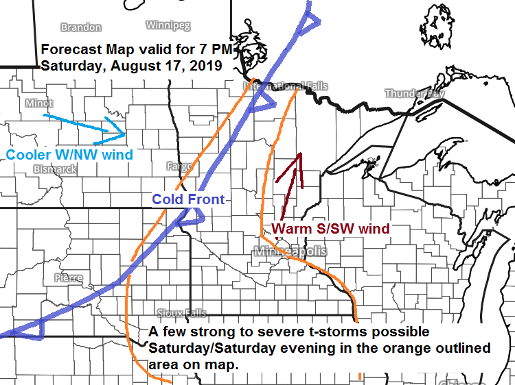
A warm day on Saturday with highs in the 70s along the North Shore to the low and mid 80s elsewhere. Dew points ranging from the upper 50s to lower 60s so not terribly humid on Saturday. Winds south to southwest 10 to 20 mph. A few showers and thunderstorms are possible Saturday in northern Minnesota, dry elsewhere under partly cloudy skies.
Showers along with a few thunderstorms Saturday night through Sunday morning as a cold front crosses the area. Heavy rainfall is possible mainly in north-central Minnesota.
Cooler weather returns Sunday with highs in the 70s along with northwest winds 10 to 20 mph.
Forecast for Duluth and Superior
.Tonight… Clear to partly cloudy. Patchy fog possible late. Low 55 to 60. Wind south to southwest 6 to 12 mph.
.Saturday… Warm. Partly cloudy. High 80 to 85. Wind south to southwest 10 to 20 mph.
.Sunday… Scattered showers possible early, otherwise partly to mostly cloudy. Cooler. High 72 to 77. Wind southwest, becoming northwest 10 to 20 mph.
Normal temperatures for August 17
- High 74
- Low 55
- Sunrise Saturday 6:09 AM CDT
- Sunset Saturday 8:16 PM CDT
Leave a Reply