Some rain is on the way! The greatest chance for rain in Duluth comes early Friday morning (well after midnight tonight) rain should end between 6-9 AM Friday.
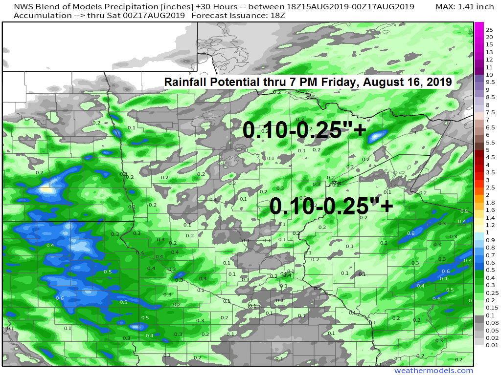
Here’s how much rain could fall tonight and Friday per model guidance. One tenth to one quarter inch of rain is possible over much of the Northland with locally higher amounts possible. Source: https://lab.weathermodels.com

Threat for severe weather and heavy rain will stay well south of the Northland tonight.

It has been a dry summer in parts of the Northland. Duluth is running nearly -2.00 inches below normal in rainfall since June 1 while International Falls is close to -1.00 inch below normal in rainfall. Note: These aren’t huge rainfall deficits, but if we don’t start to get into a more persistent rainy pattern soon, then we could see drought conditions worsen as we head through September. Source: https://droughtmonitor.unl.edu

Tonight’s rain maker is making its way through the Dakotas this afternoon, this system will head east/southeast across the upper Midwest later tonight which will increase the chances for rain in the Northland. Source: https://weather.cod.edu

18z NAM-WRF model radar forecast valid from 7 PM Thursday to 7 PM Friday. Source: https://weathermodels.com
Rain showers become more widespread later tonight into Friday morning followed by a few isolated pop-up showers Friday afternoon/early Friday evening.

Low temperature forecast for Friday morning, August 16. Source: https://graphical.weather.gov

High temperature forecast for Friday, August 16.

The next chance for rain after Friday will come Saturday night as a cold front crosses the area. A few strong storms are possible Saturday evening especially west of Duluth. Storms could continue well into the night, but they should weaken in intensity as they track farther east.

…Weather Summary…
Isolated to widely scattered showers early this evening should give way to scattered to numerous showers later this evening through the overnight. Note: The severe weather and heavy rain potential with tonight’s system stays well to our southwest, but we might be able to build up enough instability for an isolated thunderstorm in parts of the Northland tonight.
A trough of low pressure covering the Northern Plains this Thursday afternoon will move east-southeast through Friday. As this system moves closer to us, the lift in the atmosphere will become a little better for rain development by later tonight. Most of the rain should be on the light to moderate side tonight as there just isn’t a whole lot of moisture in our area, dew points mainly in the 50s with Precipitable Water of around 1.00 to 1.40 inches.
Rain moves out of the area Friday morning (before noon) but lingering moisture and some instability could cause a few showers or thunderstorms to redevelop Friday afternoon with brief downpours if you get underneath one of them.
Partly to mostly cloudy skies for tonight and Friday. Lows tonight ranging from the lower 50s to lower 60s with highs Friday ranging from the middle 60s to upper 70s, coolest temps Friday in parts of northern Wisconsin and far northeast Minnesota.
Most of the day Saturday looks dry, but rain chances will be on the increase Saturday night as a cold front makes its way through the Northland. Might have a little more instability and moisture in place for Saturday’s night cold front, this could lead to a few thunderstorms, but the chance for severe weather is very low.
Dry weather on Sunday with highs in the 70s.
Forecast for Duluth and Superior
.Tonight… Partly to mostly cloudy. Isolated showers this evening followed by occasional showers and possibly a thunderstorm overnight. Patchy fog possible late. Low 57 to 62. Wind southwest 10 to 20 mph becoming east to southeast.
.Friday… Showers possible before 10 AM with patchy fog. Partly sunny with isolated afternoon showers. High 69 to 74. Wind northeast, becoming west 10 to 15 mph.
.Saturday… Partly to mostly sunny. High 75 to 80. Wind south 10 to 20 mph.
Normal temperatures for August 16
- High 75
- Low 55
- Sunrise Friday 6:08 AM CDT
- Sunset Friday 8:17 PM CDT
Leave a Reply