A nice soaking rain in Duluth this afternoon with a rainfall total through 6 PM Monday of 0.68″. Will add to this total as some more rain is expected at times through early Wednesday morning.
Source: https://www.spc.noaa.gov


Radar loop from ~Noon to 5:50 PM Monday, August 26, 2019. Note: Radar outage continues this week in Duluth which is why the rain cuts-off on radar imagery.

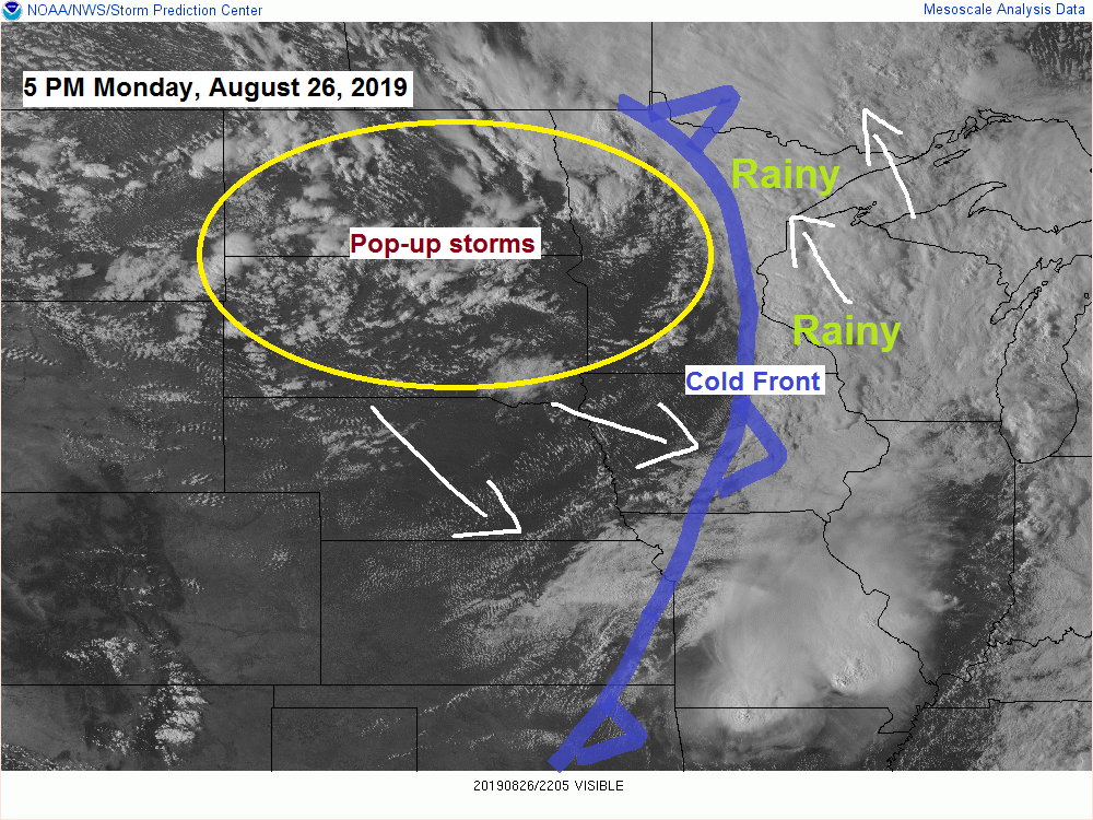
Monday’s system is starting to wrap up as it is in the process of deepening while the upper level trough begins to take on a negative tilt as it passes through the upper Midwest today.
Source: https://weather.cod.edu

Tuesday’s weather will feature some dry hours and some wet hours as we see scattered showers pass through the Northland. A few thunderstorms are also forecast to develop especially in the afternoon, these storms will be capable of producing brief downpours, occasional lightning and small hail.
Source: 12z NAM model; https://www.pivotalweather.com

18z HRRR model radar forecast valid from 7 PM Monday to 1 AM Wednesday. Source: https://weathermodels.com
Steady rain ends from SW-NE this evening with spotty showers the rest of tonight. Then with some heating on Tuesday will see showers become more widespread during the day.

Another sign we’re heading into fall are quick changes in temperatures, instead of being in a stagnant pattern for what seems like weeks at a time (summer months) we tend to see more frequent changes in temperatures during the fall months. This will be the case Wednesday into Thursday with strong cold air advection Wednesday dropping 850mb temperatures to around +2C, but this will be replaced by a strong push of warm air advection Thursday morning which will boost the 850mb temperature to around +15C, but this also won’t last long as a cold front pushes SE through the Northland Thursday afternoon with some cold air advection taking place behind this front Thursday night.
Source: 12z NAM model; https://www.tropicaltidbits.com


Low temperature forecast for Tuesday morning, August 27. Source: https://graphical.weather.gov

High temperature forecast for Tuesday, August 27.

…Weather Summary…
A steady band of rain will continue to lift north/east while it affects northeast Minnesota and northwest Wisconsin tonight, this area of rain will diminish from SW-NE this evening and will be followed by a few showers and isolated thunderstorms overnight.
Surface and upper level areas of low pressure will deepen through Wednesday as they move slowly through Ontario. One or two troughs will rotate around this system, and those troughs will affect our weather through Wednesday morning.
Expect scattered showers along with a few thunderstorms Tuesday followed by some drizzle and light rain Tuesday night into Wednesday morning.
This system pulls far enough away from our area by Wednesday afternoon with nicer weather returning at that time.
With the low deepening to our north and high pressure setting up from the Northern Rockies to Central Plains will see the pressure gradient tighten which will lead to gusty westerly winds in the Northland through Wednesday. Winds of 10 to 20 mph are likely with gusts approaching 35 mph.
Lows tonight will mainly be in the 50s with highs Tuesday ranging from around 60 to 70 degrees.
Rainfall Reports for August 25-26, 2019
Source: https://mesowest.utah.edu
Note: Totals listed below are for the 24-hour period ending around 6 PM Monday, August 26.
- Hill City, MN: 1.17″
- Grand Rapids, MN: 1.16″
- Chisholm-Hibbing, MN: 1.15″
- Moose Lake, MN: 1.03″
- Saginaw, MN: 0.98″
- Hinckley, MN: 0.92″
- Brainerd, MN: 0.89″
- Eveleth-Virginia, MN: 0.83″
- Walker, MN: 0.82″
- Bigfork, MN: 0.71″
- Pine River, MN: 0.70″
- Duluth, MN (Airport) 0.68″
- Orr, MN: 0.66″
- Cass Lake, MN: 0.63″
- Two Harbors, MN: 0.63″
- Siren, WI: 0.61″
- Silver Bay, MN: 0.58″
- Minong, WI: 0.51″
- Ely, MN: 0.48″
- Cook, MN: 0.46″
- Superior, WI (Airport) 0.45″
- International Falls, MN: 0.45″
- Solon Springs, WI: 0.36″
- Washburn, WI: 0.18″
- Grand Portage, MN: 0.11″
- Ashland, WI: 0.07″
- Isabella, MN: 0.06″
- Grand Marais, MN: 0.05″
Forecast for Duluth and Superior
.Tonight… A few showers through around Midnight, mainly dry overnight. Mostly cloudy. Low 53 to 58. Wind becoming west 10 to 20 mph.
.Tuesday… Breezy. Partly to mostly cloudy. Scattered showers. A few thunderstorms also possible. High 63 to 68. Wind southwest 15 to 25 mph.
.Wednesday… Drizzle possible early, mostly cloudy with clearing during the afternoon. Breezy. High 65 to 70. Wind west 15 to 30 mph.
Note: Weather forecast for the Silver 1000 at the Proctor Speedway on Thursday, August 29 — Dry! Partly cloudy. High 70 to 75, cooling to around 60 degrees by 9 PM. Northwest wind 15 to 25 mph.
Normal temperatures for August 27
- High 72
- Low 53
- Sunrise Tuesday 6:22 AM CDT
- Sunset Tuesday 7:58 PM CDT
Thanks for reading!
Leave a Reply