Duluth has picked up 2.39 inches of rain so far this month, this is -0.81 inches below normal. Since June 1, 9.12 inches of rain, this is -2.16 inches below normal. It’s unlikely will get enough rain by Saturday, August 31 to erase the deficit we have for August, and also for the summer of 2019.
Local Storm Reports for August 27, 2019
Source: https://www.weather.gov/dlh/
- 5:02 PM: HAIL — 0.70 inch. 1 NE Hayward, WI (Sawyer County)
- 4:02 PM: HAIL — 0.25 inch. Sanborn, WI (Ashland County)
- 2:55 PM: HAIL — 0.70 inch. 1 NE Hayward, WI (Sawyer County)
- 1:48 PM: HAIL — 0.25 inch. 3 NE Hermantown, MN (St. Louis County) A few pea size hail stones.
- 1:30 PM: HAIL — 0.70 inch. Ashland, WI (Ashland County) Half inch to dime size hail.
- 1:20 PM: HAIL — 0.25 inch. 1 W Ashland, WI (Ashland County)
- 11:30 AM: HAIL — 0.70 inch. 2 SE Glidden, WI (Ashland County) Dime size hail covering the ground. Lasted about ten minutes.
Note: Duluth had a top 5 wettest August 26 on Monday with 0.77 inches of rain. The wettest August 26 on record occurred in 2017 with 1.92 inches of rain.
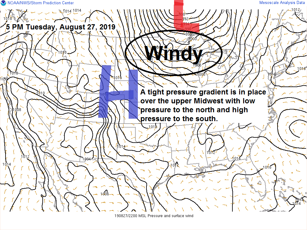
Source: https://www.spc.noaa.gov

Gales and waterspouts on Lake Superior today. A gale warning is in effect for western Lake Superior through late Wednesday morning. West gales with wave heights to 12 feet and a maximum wave height up to 17 feet possible over the open waters of western Lake Superior. Note: The strongest winds and largest waves will be east of the Duluth-Superior Harbor.


Two impressive looking low pressure systems on Goes-16 satellite imagery today. The first one is located north of Lake Superior, the other one is located northeast of New England. These systems are wrapped up nicely, a little unusual to see something like this at this time of year.
Source: https://weather.cod.edu

Wednesday will start out kinda gray and cool, but clouds are forecast to decrease from SW to NE across the Northland by Wednesday afternoon with mostly sunny skies and pleasant temperatures during the afternoon. It will be windy on Wednesday with west to northwest winds 15 to 30 mph. Note: White areas on the map below indicate clouds while the black areas indicate clear skies.
Source: 18z NAM-3km model; https://www.tropicaltidbits.com

Low temperature forecast for Wednesday morning, August 28. Source: https://graphical.weather.gov

High temperature forecast for Wednesday, August 28.

…Weather Summary…
A strong area of low pressure (~990mb) was over northern Ontario this Tuesday afternoon. This low won’t move very much as it moves over Hudson Bay the next few days. A tight pressure gradient between the low to our north and high pressure to our south will continue to produce gusty west winds through Wednesday with wind speeds of 10 to 20 mph with gusts to 35 mph.
Cold air advection continues tonight with 850mb temperatures falling to around +3C by Wednesday morning, this will be replaced by a strong push of warm air advection early Thursday morning as 850mb temperatures climb to around +10 to +18C, this won’t last very long, however, as another shot of cold air advection pours into the Northland during the day Thursday although not quite as intense as what we have tonight.
With the changing temperatures, wind will be an issue the next few days, just another sign that fall is approaching.
Lows tonight will range from the middle 40s to middle 50s with highs Wednesday in the lower 60s in far northeast Minnesota to the middle 60s to around 70 degrees elsewhere.
Mostly cloudy skies tonight with some light rain and drizzle which could linger a few hours past sunrise Wednesday, then will see increasing amounts of sun by Wednesday afternoon.
A cold front moves quickly through the Northland Thursday morning, we could see a few showers or thunderstorms develop as that front moves through. Instability doesn’t look very impressive with CAPE on the low side, but the mid level lapse rates steepen quite a bit, possibly in the 7.0-8.0 c/km range so we could see a few thunderstorms develop in parts of the area roughly in the 2 AM to 11 AM time frame on Thursday.
Dry weather is expected Thursday afternoon into Friday.
Forecast for Duluth and Superior
.Tonight… Breezy. Mostly cloudy. Some light rain or drizzle possible. Low 48 to 53. Wind west 15 to 25 mph.
.Wednesday… Breezy. Mostly cloudy early with some drizzle possible followed by mostly sunny skies in the afternoon. High 65 to 70. Wind west 15 to 30 mph.
.Thursday… Breezy. Isolated showers or thunderstorms possible before 10 AM, otherwise partly cloudy. High 68 to 73. Wind southwest 15 to 25 mph early, becoming northwest.
Normal temperatures for August 28
- High 72
- Low 53
- Sunrise Wednesday 6:23 AM CDT
- Sunset Wednesday 7:56 PM CDT
Thanks for reading!
Leave a Reply