Some more rain is on the way for Thursday.
Source: 18z NAM-WRF model; https://weathermodels.com

Here’s a look at Thursday’s radar forecast per 18z NAM-WRF model — Occasional showers through the day with some dry hours mixed in.

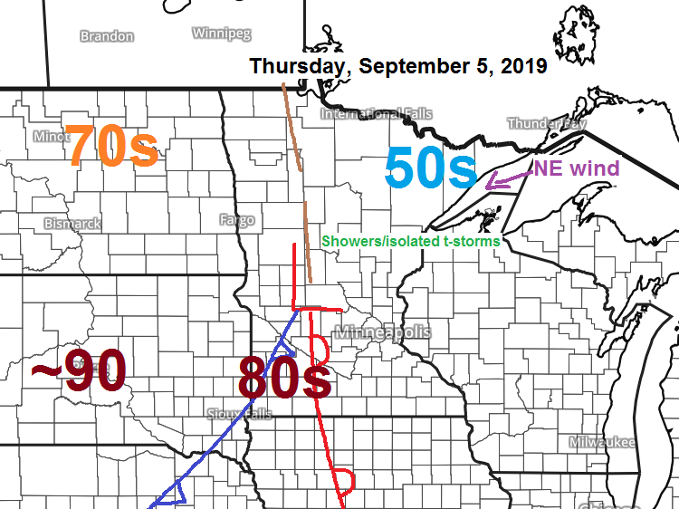
If you like warm weather, head to southern Minnesota or South Dakota Thursday where highs are forecast to be in the middle 80s to lower 90s!

Didn’t have enough energy to type a weather report on Tuesday due to coming down with a massive cold the past few days which has zapped my energy, but hopefully this garbage peaked on Tuesday, but will see. Feeling a tiny bit better today, at least well enough to get back to blogging. Anyways here’s a look at rainfall and storm reports from Monday evening through Tuesday, September 2-3, 2019.
Rainfall Reports from around the Northland; Source https://mesowest.utah.edu
September 2-3, 2019
- Hayward, WI: 1.86″
- Glidden, WI: 1.56″
- Clam Lake, WI: 1.34″
- Minong, WI: 1.18″
- Hinckley, MN: 1.03″
- Brainerd, MN: 0.72″
- Ashland, WI: 0.65″
- Solon Springs, WI: 0.60″
- Two Harbors, MN: 0.58″
- Washburn, WI: 0.56″
- Superior, WI (Airport) 0.56″
- Pine River, MN: 0.55″
- Grand Portage, MN: 0.54″
- International Falls, MN: 0.53″
- Moose Lake, MN: 0.51″
- Barnes, WI: 0.48″
- Grand Marais, MN: 0.48″
- Saginaw, MN: 0.46″
- Hill City, MN: 0.44″
- Duluth, MN (Airport) 0.40″
- Orr, MN: 0.37″
- Isabella, MN: 0.36″
- Ely, MN: 0.35″
- Walker, MN: 0.29″
- Silver Bay, MN: 0.28″
- Siren, WI: 0.24″
- Cass Lake, MN: 0.22″
- Bigfork, MN: 0.19″
- Chisholm-Hibbing, MN: 0.17″
Local Storm Reports from September 2-3, 2019
Source: https://www.weather.gov/dlh/
- 1:23 AM: Non-Thunderstorm Wind Damage. 1 NE Bayfield, WI (Bayfield County) 5 inch diameter tree limb down.
- 12:50 AM: Thunderstorm Wind Gust. 45 mph. 2 ENE Hayward, WI (Sawyer County)
- 12:45 AM: Non-Thunderstorm Wind Gust. 51 mph. La Pointe.
- 11:13 PM: Non-Thunderstorm Wind Gust. 53 mph. Report from the Duluth International Airport. Wake low winds.
- 8:39 PM: Thunderstorm Wind Gust. 53 mph. 3 NE Brainerd, MN (Crow Wing County)
Low temperature forecast for Thursday morning, September 5. Source: https://graphical.weather.gov

High temperature forecast for Thursday, September 5

Dorian is still out there, but its finally moving quicker than it has been the last few days. Here’s a look at Hurricane Dorian per Goes-16 infrared satellite imagery from Wednesday, September 4, 2019.
Source: https://www.tropicaltidbits.com

Hurricane Dorian update 5 PM EDT Wednesday, September 4, 2019; source: https://www.nhc.noaa.gov
- Location: About 150 miles south of Charleston, South Carolina; about 275 miles south-southwest of Wilmington, North Carolina.
- Maximum sustained winds: 110 mph
- Present movement: north-northwest at 8 mph
- Minimum central pressure: 961 mb/28.38″
The center (eye) of Dorian is forecast to brush the east coast of the Carolinas through Friday afternoon, but Dorian could make landfall on Friday in North Carolina. Dorian will continue to pick up forward speed through the weekend as it passes east of Maine on Saturday.

…Weather Summary…
Partly to mostly cloudy skies for tonight with scattered showers and isolated thunderstorms developing while spreading E-SE out of north-central Minnesota overnight. Lows will be in the middle 40s to middle 50s with southerly winds 5 to 15 mph.
Occasional showers along with a few thunderstorms for Thursday under mostly cloudy skies. Not expecting an all day rain Thursday, but do expect some rain from time to time. Temperatures will be on the cool side as will be north of a warm front and area of low pressure which means easterly winds. Highs Thursday will be in the 50s and 60s with 70s possible in extreme southern areas from Brainerd to Pine City.
As for the thunderstorm potential Thursday, the setup isn’t that favorable for convection, although there will be some elevated CAPE that builds into our area during the day, but the steeper lapse rates associated with the elevated mixed layer will remain south of our area which will likely be a limiting factor on getting more widespread thunderstorm activity to develop up in our area. With that said, if we can get enough CAPE to sneak into our area, then we could see a few strong storms with a hail threat, mainly around the Brainerd Lakes, Hinckley and Pine City areas on Thursday.
This weekend overall is looking dry, but there are two trouble spots, one being Friday afternoon into early Friday evening when we could see a few spotty showers in the Northland as a cold front moves south through the area. Then on Saturday a low pressure system moves E-SE out of the western High Plains. Forecast models show the rain with this system passing south of our area on Saturday with mainly dry weather expected in northeast Minnesota and northwest Wisconsin the way it looks now.
Highs Friday in the middle 60s to lower 70s, cooler Saturday with highs in the mid 50s to mid 60s.
Forecast for Duluth and Superior
.Tonight… Partly to mostly cloudy. Low 50 to 55. Wind becoming south 5 to 15 mph.
.Thursday… Occasional showers. A thunderstorm also possible. Mostly cloudy with areas of fog possible. High 60 to 65. Wind east 10 to 20 mph.
.Friday… Partly sunny. Isolated showers possible late. High 65 to 70. Wind west 10 to 15 mph.
Normal temperatures for Thursday
- High 69
- Low 50
- Sunrise Thursday 6:33 AM CDT
- Sunset Thursday 7:41 PM CDT
Thanks for reading!
Leave a Reply