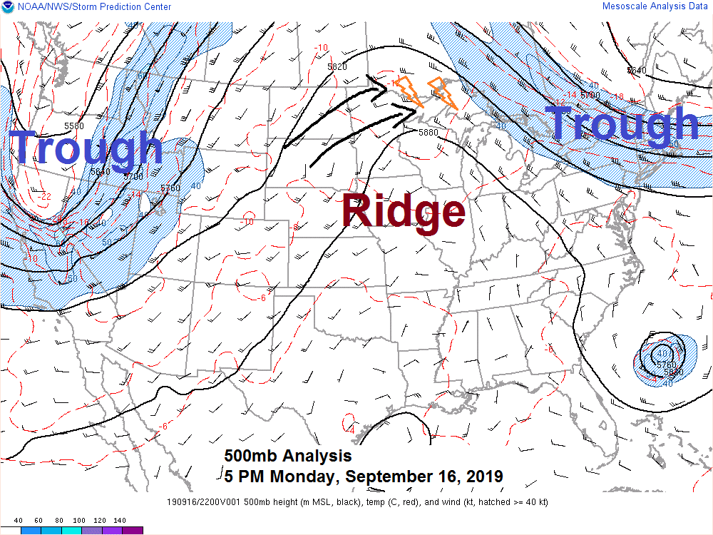
Big time ridge in place across the Midwest with troughs covering the western U.S. and northeast U.S. today per 500mb analysis from Monday, September 16, 2019. Source: https://www.spc.noaa.gov

It’s quite unstable today with elevated instability pushing 4000 J/kg in parts of North Dakota late this Monday afternoon. A few thunderstorms developed late this afternoon in extreme northeast Minnesota east of the greatest instability. Note: See radar image below.


Goes-16 visible satellite imagery is a busy one today with fog and low clouds pushing west/northwest over Lake Superior while clouds build in from west to east, and late this afternoon we saw a few thunderstorms explode in the Arrowhead of Minnesota (Cook County) Source: https://weather.cod.edu

Someone forgot to tell Lake Superior it was supposed to be a warm week by the lake. That pesky lake breeze (marine layer) and micro-climate keeping it much cooler and quite dreary near Lake Superior with low clouds and fog once again today while summer warmth and humidity is occurring farther inland from Lake Superior.
Note: No record highs were set in the Northland today, Monday, September 16, 2019 but Hibbing and Brainerd both had their 3rd warmest September 16 on record.
Here are the record highs for September 16, and the year they were set.
- Ashland: 94F (1948)
- Brainerd: 91F (1948)
- Duluth: 89F (1948)
- Hibbing: 87F (1948)
- International Falls: 87F (2018)

18z NAM-WRF model radar forecast valid from 7 AM Tuesday to 12 PM Wednesday. Source: https://weathermodels.com
Scattered showers along with a few thunderstorms are expected Tuesday especially in north-central and northeast Minnesota into far northwest Wisconsin.
Then late Tuesday night into early Wednesday morning there is potential for more showers and thunderstorms to develop in northern/central Minnesota, this activity would then push off to the east Wednesday morning.

Low temperature forecast for Tuesday morning, September 17. Source: https://graphical.weather.gov

High temperature forecast for Tuesday, September 17

Watching a late week system which moves east out of the Rockies, this one could affect the Northland Friday into Saturday with showers and some thunderstorms. Source: 18z NAM model; https://weather.cod.edu

Temperature and Precipitation report for Duluth, Minnesota for the period September 8-14, 2019
High Temperatures/Departure from Normal
- 9/8: 62F/-6 degrees below normal
- 9/9: 61F/-7 degrees below normal
- 9/10: 73F/+6 degrees above normal
- 9/11: 60F/-7 degrees below normal
- 9/12: 55F/-12 degrees below normal
- 9/13: 60F/-6 degrees below normal
- 9/14: 69F/+3 degrees above normal
Low Temperatures/Departure from Normal
- 9/8: 48F/-1 degree below normal
- 9/9: 52F/+3 degrees above normal
- 9/10: 56F/+8 degrees above normal
- 9/11: 50F/+2 degrees above normal
- 9/12: 50F/+2 degrees above normal
- 9/13: 51F/+4 degrees above normal
- 9/14: 46F/-1 degree below normal
Average temperature for the week of September 8: 56.6 degrees; -0.9 degrees below normal. Note: Last week was the 4th week in a row where the average temperature was below normal in Duluth.
- Total Precipitation: 2.67″
- Normal: 1.00″
- Departure: +1.67″ above normal
State Average for Minnesota for the week of September 8, 2019
- Temperature: 58.7 degrees
- Departure: -2.2 degrees below normal
- Precipitation: 3.36″
- Departure: +2.62″ above normal
Temperature departure map for the week of September 8, 2019. Source: https://sercc.com/

Precipitation departure map for the week of September 8, 2019.

…Weather Summary…
Two rounds of showers and thunderstorms possible Tuesday into early Wednesday.
A warm front will head into central Minnesota on Tuesday. There will be plenty of moisture and instability near this front, and this combined with a disturbance lifting northeast out of eastern South Dakota should generate some showers and a few thunderstorms in parts of the Northland on Tuesday. Note: Probably won’t be much of a severe threat with the storms on Tuesday, but occasional lightning and downpours are possible. Lots of juice out there on Tuesday with dew points away from Lake Superior of 65 to 70 degrees while PWATS across the entire Northland range from around 1.30 to 1.90 inches (impressive for mid September!) this raises the threat for getting some heavy rain with some of the showers on Tuesday.
Late Tuesday night into Wednesday morning will find a cold front moving east out of the central Dakotas while low pressure heads into southern Manitoba. Showers and thunderstorms are forecast to develop late Tuesday night in western or central Minnesota, this activity could hold together and move through much of the Northland early Wednesday morning.
There will be a strong low level jet out of the south approaching 60 knots Tuesday night ahead of the Northern Plains cold front which will help maintain an unstable airmass over the upper Midwest with CAPE of 1000 to around 2500 J/kg. Whether or not we get any severe weather late Tuesday night remains to be seen as the stronger winds aloft remain generally behind the cold front or west of the best instability, so storms Tuesday night may be more of a heavy rain and lightning threat instead of a wind/hail threat unless we see a squall line develop, if that occurs then an increase wind threat is possible in parts of the Northland.
Cold front will move through most of the Northland on Wednesday but could wash out as it does so since there won’t be much of a temperature change from ahead to behind this cold front. A few showers and thunderstorms could redevelop Wednesday in a humid/unstable environment in eastern Minnesota and northwest Wisconsin.
Low temperatures tonight will be in the 60s (very mild for this time of year) cooler 50s near Lake Superior tonight. Highs Tuesday in the 70s to lower 80s but it will be cooler once again near Lake Superior.
We should get a wind shift on Wednesday (SW wind) if this happens, then highs will get into the 70s even near Lake Superior.
Forecast for Duluth and Superior
.Tonight… Fog. Mostly cloudy. Low 55 to 60, cooler near Lake Superior. Wind east to southeast 10 to 15 mph.
.Tuesday… Areas of fog. Mostly cloudy. Occasional showers and isolated thunderstorms possible. High 68 to 73, cooler near Lake Superior. Wind southeast 10 to 15 mph.
.Wednesday… Showers or thunderstorms possible mainly early in the day. Partly to mostly cloudy. High 72 to 77. Wind south, becoming southwest 10 to 20 mph.
Normal temperatures for Tuesday
- High 65
- Low 46
- Sunrise Tuesday 6:49 AM CDT
- Sunset Tuesday 7:17 PM CDT
Thanks for reading!
Leave a Reply