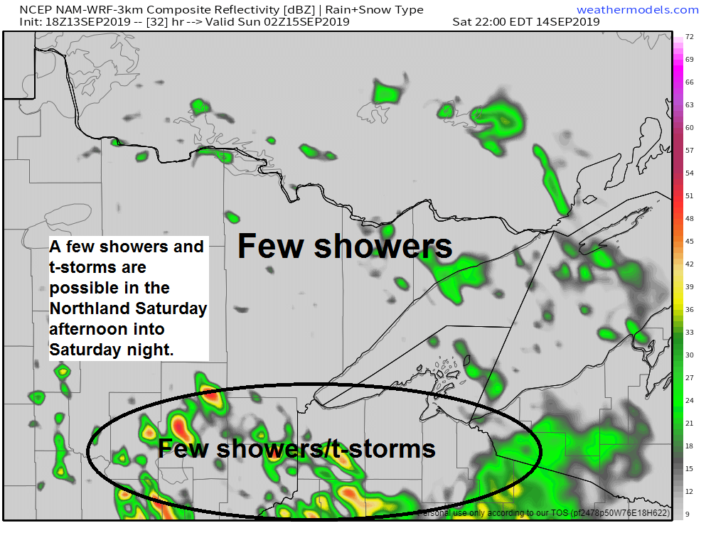
Saturday morning should be dry in the Northland, but chances for a few showers and thunderstorms will increase Saturday afternoon into Saturday night.

18z NAM-WRF model radar forecast valid from 7 AM Saturday to 7 AM Sunday. Source: https://weathermodels.com

A strong low pressure system continues to impact the Northland today as it moves E-NE across Ontario. Check it out on Goes-16 water vapor satellite imagery.
Source: https://weather.cod.edu

Low temperature forecast for Saturday morning, September 14. Source: https://graphical.weather.gov

High temperature forecast for Saturday, September 14

Record rainfall at International Falls on Thursday. Rainfall total of 1.48 inches on September 12, 2019 — The previous wettest September 12 occurred in 1924 with 0.75 inches of precipitation.
Rainfall Reports for September 12-13, 2019
Source: https://www.weather.gov/dlh/
- Littlefork, MN: 3.29″
- Cook, MN: 2.46″
- Grand Portage, MN: 1.98″
- 2 S Tower, MN: 1.95″
- Esko, MN: 1.75″
- International Falls, MN: 1.70″
- Washburn, WI: 1.60″
- Morgan Park, MN: 1.54″
- Barnes, WI: 1.53″
- Silver Bay, MN: 1.51″
- Hibbing, MN: 1.51″
- Pine River, MN: 1.47″
- Wolfridge, MN (ELC) 1.42″
- Minong, WI: 1.41″
- Spooner, WI: 1.41″
- Aurora, MN: 1.36″
- Bayfield, WI: 1.27″
- South Range, WI: 1.22″
- Cass Lake, MN: 1.19″
- Northome, MN: 1.08″
- Kettle River, MN: 1.01″
- Ashland, WI: 0.97″
- Deer River, MN: 0.85″
- Walker, MN: 0.85″
- Duluth, MN (Airport) 0.83″
- Ely, MN: 0.83″
- Isabella, MN: 0.72″
- Two Harbors, MN: 0.68″
- Danbury, WI: 0.67″
- Babbitt, MN: 0.66″
- Odanah, WI: 0.65″
- Grand Rapids, MN: 0.61″
- Hill City, MN: 0.58″
- Glidden, WI: 0.58″
- Grand Marais, MN: 0.57″
- Brainerd, MN: 0.56″
- Cotton, MN: 0.52″
- Moose Lake, MN: 0.44″
- Clam Lake, WI: 0.37″
Rainfall estimates zoomed in on the Duluth area.

Zoomed out view of rainfall estimates across the Northland.

September 2019 is off to a cool and wet start in the Northland. Note: Stats below are from September 1 through 12.
Duluth
- Average temperature: 58.6 degrees
- Departure: -0.6 degrees below normal
- Total precipitation: 3.42″
- Departure: +1.76″ above normal
Note: 22.59″ of precipitation so far this year (thru September 12) +0.23″ above normal.
International Falls
- Average temperature: 53.4 degrees
- Departure: -4.0 degrees below normal
- Total precipitation: 3.42″
- Departure: +2.21″ above normal
Here’s the temperature anomaly map for September 1-12, 2019.
Note: Will likely see the below average area across the upper Midwest shrink and modify a bit next week due to the warmer temps that are expected next week.
Source: https://lab.weathermodels.com/

Next week’s weather pattern still looks like a warm one for the Northland with an upper level ridge located to our southeast and an upper level trough over the Pacific northwest. A warm southwesterly flow aloft will occur between the ridge and trough.
Source: 12z European model 9.13.19; https://www.pivotalweather.com

Here’s what the temperature anomaly forecast looks like for next week given the pattern on the map above.
Source: 12z GEFS model 9.13.19; https://www.tropicaltidbits.com/

…Weather Summary…
Low pressure of 1002mb was located just northwest of Lake Superior as of 5 PM Friday. Cool and blustery weather in the Northland today with spotty showers and drizzle. Late Friday afternoon temperatures were in the upper 40s to middle 50s with west winds 10 to 20 mph with gusts to 30 mph.
Low pressure will move into Hudson Bay by daybreak, as the low continues to pull farther away from our area, skies should begin to clear tonight from west to east. Lows tonight will mainly be in the 40s, but a few 30s are possible in the typical cool spots. Breezy west winds will continue most of the night at 10 to 20 mph with gusts to 30 mph before Midnight.
Quick weather changes take place Saturday. Should be dry during the morning, and possibly into the afternoon, but warm air and moisture advection will take place later in the day as a quick moving low with its warm front and cold front move across the upper Midwest. Instability will begin to increase ahead of this system from SW-NE with elevated CAPE possibly up to around 500 to 1000 J/kg across southern portions of the Northland by Saturday evening. Somewhat steep mid level lapse rates of around 7.0 c/km will also be found in parts of the area on Saturday. We should see at least isolated to widely scattered coverage of showers in the area Saturday afternoon into Saturday night with the greatest chance for a few thunderstorms over east-central Minnesota and northwest Wisconsin the way it looks now. Note: Hail will be a threat if storms become strong enough Saturday night in east-central Minnesota and northwest Wisconsin. Highs Saturday will be in the middle 60s to lower 70s with cooler temps along the North Shore of Lake Superior.
Sunday looks dry with highs in the mid 60s to upper 70s (warmest temps around the Walker and Brainerd Lakes)
Note: Although most of the Northland will have a warm few days next week, it’s possible a lake wind will keep it cooler near Lake Superior, at least on Monday, but a lake wind is possible past Monday depending on how the pattern sets up. With it turning more humid next week, fog could be an issue near Lake Superior if winds are out of the east.
Forecast for Duluth and Superior
.Tonight… Breezy. Isolated showers and drizzle early. Mostly cloudy with some clearing late. Low 45 to 50. Wind west 15 to 30 mph decreasing to 10 to 15 mph late.
.Saturday… Partly to mostly cloudy. Isolated showers possible late. High 64 to 69. Wind southwest 10 to 15 mph becoming east.
.Saturday night… Mostly cloudy. A few showers or thunderstorms possible. Low 50 to 55. Wind east 10 to 15 mph.
.Sunday… Partly to mostly cloudy. High 70 to 75. Wind west 10 to 15 mph.
Normal temperatures for Saturday
- High 66
- Low 47
- Sunrise Saturday 6:45 AM CDT
- Sunset Saturday 7:23 PM CDT
Thanks for reading!
Leave a Reply